|
|
|
Advertisements:
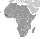
GeographyLocation
Western Africa, bordering the North Atlantic Ocean, between Guinea-Bissau and Sierra Leone Geographic coordinates
11 00 N, 10 00 W
Map references
Africa
Area World Ranking: 79
Total 245,857 sq km
Land 245,717 sq km Water 140 sq km Area - comparative
Slightly smaller than Oregon
Land boundaries
Total 3,399 km
Border countries Cote d'Ivoire 610 km, Guinea-Bissau 386 km, Liberia 563 km, Mali 858 km, Senegal 330 km, Sierra Leone 652 km Coastline
320 km
Maritime claims
Territorial sea 12 nm
Exclusive economic zone 200 nm Climate
Generally hot and humid; monsoonal-type rainy season (June to November) with southwesterly winds; dry season (December to May) with northeasterly harmattan winds Terrain
Generally flat coastal plain, hilly to mountainous interior Elevation extremes
Lowest point Atlantic Ocean 0 m
Highest point Mont Nimba 1,752 m Natural resources
Bauxite, iron ore, diamonds, gold, uranium, hydropower, fish, salt Land use
Arable land 4.47%
Permanent crops 2.64% Other 92.89% (2005) Irrigated land
950 sq km (2003)
Total renewable water resources
226 cu km (1987)
Freshwater withdrawal (domestic/industrial/agricultural)
Total 1.51 cu km/yr (8%/2%/90%)
Per capita 161 cu m/yr (2000) Natural hazards
Hot, dry, dusty harmattan haze may reduce visibility during dry season Environment - current issues
Deforestation; inadequate supplies of potable water; desertification; soil contamination and erosion; overfishing, overpopulation in forest region; poor mining practices have led to environmental damage Environment - international agreements
Party to
Biodiversity, Climate Change, Climate Change-Kyoto Protocol, Desertification, Endangered Species, Hazardous Wastes, Law of the Sea, Ozone Layer Protection, Ship Pollution, Wetlands, Whaling Signed, but not ratified None of the selected agreements Geography - note
The Niger and its important tributary the Milo have their sources in the Guinean highlands
Comments
Add a new comment: |
Advertisement
Members area
Guinea (Conakry):
 
GPS points from Guinea (Conakry)
|
||||||||

 Guinea has had a history of authoritarian rule since gaining its independence from France in 1958. Lansana CONTE came to power in 1984 when the military seized the government after the death of the first president, Sekou TOURE. Guinea did not hold democratic elections until 1993 when Gen. CONTE (head of the military government) was elected president of the civilian government. He was reelected in 1998 and again in 2003, though all the polls were marred by irregularities. History repeated itself in December 2008 when following President CONTE's death, Capt. Moussa Dadis CAMARA led a military coup, seizing power and suspending the constitution. His unwillingness to yield to domestic and international pressure to step down led to heightened political tensions that culminated in September 2009 when presidential guards opened fire on an opposition rally killing more than 150 people, and in early December 2009 when CAMARA was wounded in an assassination attempt and evacuated to Morocco and subsequently to Burkina Faso. A transitional government led by General Sekouba KONATE held democratic elections in 2010 and Alpha CONDE was elected president in the country's first free and fair elections since independence.