|
|
|
Advertisements:
GeographyLocation
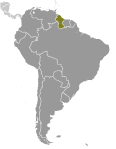
Northern South America, bordering the North Atlantic Ocean, between Suriname and Venezuela Geographic coordinates
5 00 N, 59 00 W
Map references
South America
Area World Ranking: 85
Total 214,969 sq km
Land 196,849 sq km Water 18,120 sq km Area - comparative
Slightly smaller than Idaho
Land boundaries
Total 2,949 km
Border countries Brazil 1,606 km, Suriname 600 km, Venezuela 743 km Coastline
459 km
Maritime claims
Territorial sea 12 nm
Exclusive economic zone 200 nm Continental shelf 200 nm or to the outer edge of the continental margin Climate
Tropical; hot, humid, moderated by northeast trade winds; two rainy seasons (May to August, November to January) Terrain
Mostly rolling highlands; low coastal plain; savanna in south Elevation extremes
Lowest point Atlantic Ocean 0 m
Highest point Mount Roraima 2,835 m Natural resources
Bauxite, gold, diamonds, hardwood timber, shrimp, fish Land use
Arable land 2.23%
Permanent crops 0.14% Other 97.63% (2005) Irrigated land
1,500 sq km (2003)
Total renewable water resources
241 cu km (2000)
Freshwater withdrawal (domestic/industrial/agricultural)
Total 1.64 cu km/yr (2%/1%/98%)
Per capita 2,187 cu m/yr (2000) Natural hazards
Flash flood threat during rainy seasons Environment - current issues
Water pollution from sewage and agricultural and industrial chemicals; deforestation Environment - international agreements
Party to
Biodiversity, Climate Change, Climate Change-Kyoto Protocol, Desertification, Endangered Species, Hazardous Wastes, Law of the Sea, Ozone Layer Protection, Ship Pollution, Tropical Timber 83, Tropical Timber 94 Signed, but not ratified None of the selected agreements Geography - note
The third-smallest country in South America after Suriname and Uruguay; substantial portions of its western and eastern territories are claimed by Venezuela and Suriname respectively
Comments
Add a new comment: |
Advertisement
Members area
Guyana (Georgetown):
 
GPS points from Guyana (Georgetown)
|
||||||||

 Originally a Dutch colony in the 17th century, by 1815 Guyana had become a British possession. The abolition of slavery led to black settlement of urban areas and the importation of indentured servants from India to work the sugar plantations. This ethnocultural divide has persisted and has led to turbulent politics. Guyana achieved independence from the UK in 1966, and since then it has been ruled mostly by socialist-oriented governments. In 1992, Cheddi JAGAN was elected president in what is considered the country's first free and fair election since independence. After his death five years later, his wife, Janet JAGAN, became president but resigned in 1999 due to poor health. Her successor, Bharrat JAGDEO, was reelected in 2001 and again in 2006. Donald RAMOTAR was elected president in 2011.