|
|
Advertisements:
CommunicationsTelephones - main lines in use World Ranking: 9
32.685 million (2011)
Telephones - mobile cellular World Ranking: 2
893.862 million (2011)
Telephone system
General assessment
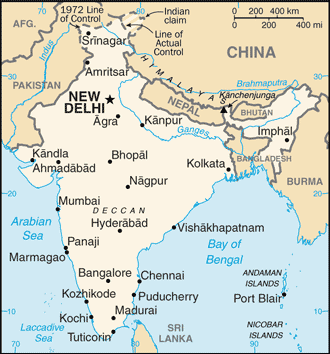
Supported by recent deregulation and liberalization of telecommunications laws and policies, India has emerged as one of the fastest growing telecom markets in the world; total telephone subscribership base exceeded 900 million in 2011, an overall teledensity of roughly 75%, and subscribership is currently growing more than 20 million per month; urban teledensity now exceeds 100% and rural teledensity is steadily growing Domestic Mobile cellular service introduced in 1994 and organized nationwide into four metropolitan areas and 19 telecom circles each with multiple private service providers and one or more state-owned service providers; in recent years significant trunk capacity added in the form of fiber-optic cable and one of the world's largest domestic satellite systems, the Indian National Satellite system (INSAT), with 6 satellites supporting 33,000 very small aperture terminals (VSAT) International Country code - 91; a number of major international submarine cable systems, including Sea-Me-We-3 with landing sites at Cochin and Mumbai (Bombay), Sea-Me-We-4 with a landing site at Chennai, Fiber-Optic Link Around the Globe (FLAG) with a landing site at Mumbai (Bombay), South Africa - Far East (SAFE) with a landing site at Cochin, the i2i cable network linking to Singapore with landing sites at Mumbai (Bombay) and Chennai (Madras), and Tata Indicom linking Singapore and Chennai (Madras), provide a significant increase in the bandwidth available for both voice and data traffic; satellite earth stations - 8 Intelsat (Indian Ocean) and 1 Inmarsat (Indian Ocean region); 9 gateway exchanges operating from Mumbai (Bombay), New Delhi, Kolkata (Calcutta), Chennai (Madras), Jalandhar, Kanpur, Gandhinagar, Hyderabad, and Ernakulam Broadcast media
Doordarshan, India's public TV network, operates about 20 national, regional, and local services; a large and increasing number of privately-owned TV stations are distributed by cable and satellite service providers; by 2011, more than 100 million homes had access to cable and satellite TV offering more than 700 TV channels; government controls AM radio with All India Radio operating domestic and external networks; news broadcasts via radio are limited to the All India Radio Network; since 2000, privately-owned FM stations have been permitted and their numbers have increased rapidly (2007) Internet country code
.in
Internet hosts World Ranking: 16
6.738 million (2010)
Internet users World Ranking: 6
61.338 million (2009)
Comments
Add a new comment: |
Advertisement
Members area
India (New Delhi):
 
GPS points from India (New Delhi)
|
||||||||

 The Indus Valley civilization, one of the world's oldest, flourished during the 3rd and 2nd millennia B.C. and extended into northwestern India. Aryan tribes from the northwest infiltrated onto the Indian subcontinent about 1500 B.C.; their merger with the earlier Dravidian inhabitants created the classical Indian culture. The Maurya Empire of the 4th and 3rd centuries B.C. - which reached its zenith under ASHOKA - united much of South Asia. The Golden Age ushered in by the Gupta dynasty (4th to 6th centuries A.D.) saw a flowering of Indian science, art, and culture. Islam spread across the subcontinent over a period of 700 years. In the 10th and 11th centuries, Turks and Afghans invaded India and established the Delhi Sultanate. In the early 16th century, the Emperor BABUR established the Mughal Dynasty which ruled India for more than three centuries. European explorers began establishing footholds in India during the 16th century. By the 19th century, Great Britain had become the dominant political power on the subcontinent. The British Indian Army played a vital role in both World Wars. Nonviolent resistance to British rule, led by Mohandas GANDHI and Jawaharlal NEHRU, eventually brought about independence in 1947. Communal violence led to the subcontinent's bloody partition, which resulted in the creation of two separate states, India and Pakistan. The two countries have fought three wars since independence, the last of which in 1971 resulted in East Pakistan becoming the separate nation of Bangladesh. India's nuclear weapons tests in 1998 caused Pakistan to conduct its own tests that same year. In November 2008, terrorists originating from Pakistan conducted a series of coordinated attacks in Mumbai, India's financial capital. In January 2011, India assumed a nonpermanent seat in the UN Security Council for the 2011-12 term. Despite pressing problems such as significant overpopulation, environmental degradation, extensive poverty, and widespread corruption, rapid economic development is fueling India's rise on the world stage.