|
|
|
Advertisements:
GeographyLocation
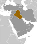
Middle East, bordering the Persian Gulf, between Iran and Kuwait Geographic coordinates
33 00 N, 44 00 E
Map references
Middle East
Area World Ranking: 59
Total 438,317 sq km
Land 437,367 sq km Water 950 sq km Area - comparative
Slightly more than twice the size of Idaho Land boundaries
Total 3,650 km
Border countries Iran 1,458 km, Jordan 181 km, Kuwait 240 km, Saudi Arabia 814 km, Syria 605 km, Turkey 352 km Coastline
58 km
Maritime claims
Territorial sea 12 nm
Continental shelf Not specified Climate
Mostly desert; mild to cool winters with dry, hot, cloudless summers; northern mountainous regions along Iranian and Turkish borders experience cold winters with occasionally heavy snows that melt in early spring, sometimes causing extensive flooding in central and southern Iraq Terrain
Mostly broad plains; reedy marshes along Iranian border in south with large flooded areas; mountains along borders with Iran and Turkey Elevation extremes
Lowest point Persian Gulf 0 m
Highest point Unnamed peak; 3,611 m; note - this peak is neither Gundah Zhur 3,607 m nor Kuh-e Hajji-Ebrahim 3,595 m Natural resources
Petroleum, natural gas, phosphates, sulfur Land use
Arable land 13.12%
Permanent crops 0.61% Other 86.27% (2005) Irrigated land
35,250 sq km (2003)
Total renewable water resources
96.4 cu km (1997)
Freshwater withdrawal (domestic/industrial/agricultural)
Total 42.7 cu km/yr (3%/5%/92%)
Per capita 1,482 cu m/yr (2000) Natural hazards
Dust storms; sandstorms; floods Environment - current issues
Government water control projects have drained most of the inhabited marsh areas east of An Nasiriyah by drying up or diverting the feeder streams and rivers; a once sizable population of Marsh Arabs, who inhabited these areas for thousands of years, has been displaced; furthermore, the destruction of the natural habitat poses serious threats to the area's wildlife populations; inadequate supplies of potable water; development of the Tigris and Euphrates rivers system contingent upon agreements with upstream riparian Turkey; air and water pollution; soil degradation (salination) and erosion; desertification Environment - international agreements
Party to
Biodiversity, Law of the Sea, Ozone Layer Protection Signed, but not ratified Environmental ModificationGeography - note
Strategic location on Shatt al Arab waterway and at the head of the Persian Gulf
Comments
Add a new comment: |
Advertisement
Members area
Iraq (Baghdad):
 
GPS points from Iraq (Baghdad)
|
||||||||

 Formerly part of the Ottoman Empire, Iraq was occupied by Britain during the course of World War I; in 1920, it was declared a League of Nations mandate under UK administration. In stages over the next dozen years, Iraq attained its independence as a kingdom in 1932. A "republic" was proclaimed in 1958, but in actuality a series of strongmen ruled the country until 2003. The last was SADDAM Husayn. Territorial disputes with Iran led to an inconclusive and costly eight-year war (1980-88). In August 1990, Iraq seized Kuwait but was expelled by US-led, UN coalition forces during the Gulf War of January-February 1991. Following Kuwait's liberation, the UN Security Council (UNSC) required Iraq to scrap all weapons of mass destruction and long-range missiles and to allow UN verification inspections. Continued Iraqi noncompliance with UNSC resolutions over a period of 12 years led to the US-led invasion of Iraq in March 2003 and the ouster of the SADDAM Husayn regime. US forces remained in Iraq under a UNSC mandate through 2009 and under a bilateral security agreement thereafter, helping to provide security and to train and mentor Iraqi security forces. In October 2005, Iraqis approved a constitution in a national referendum and, pursuant to this document, elected a 275-member Council of Representatives (COR) in December 2005. The COR approved most cabinet ministers in May 2006, marking the transition to Iraq's first constitutional government in nearly a half century. In January 2009, Iraq held elections for provincial councils in all governorates except for the three governorates comprising the Kurdistan Regional Government and Kirkuk Governorate. Iraq held a national legislative election in March 2010 - choosing 325 legislators in an expanded COR - and, after nine months of deadlock the COR approved the new government in December 2010. Nearly nine years after the start of the Second Gulf War in Iraq, US military operations there ended in mid-December 2011.