|
|
|
Advertisements:
GeographyLocation
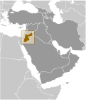
Middle East, northwest of Saudi Arabia, between Israel (to the west) and Iraq Geographic coordinates
31 00 N, 36 00 E
Map references
Middle East
Area World Ranking: 112
Total 89,342 sq km
Land 88,802 sq km Water 540 sq km Area - comparative
Slightly smaller than Indiana
Land boundaries
Total 1,635 km
Border countries Iraq 181 km, Israel 238 km, Saudi Arabia 744 km, Syria 375 km, West Bank 97 km Coastline
26 km
Maritime claims
Territorial sea 3 nm
Climate
Mostly arid desert; rainy season in west (November to April) Terrain
Mostly desert plateau in east, highland area in west; Great Rift Valley separates East and West Banks of the Jordan River Elevation extremes
Lowest point Dead Sea -408 m
Highest point Jabal Umm ad Dami 1,854 m Natural resources
Phosphates, potash, shale oil
Land use
Arable land 3.32%
Permanent crops 1.18% Other 95.5% (2005) Irrigated land
820 sq km (2003)
Total renewable water resources
0.9 cu km (1997)
Freshwater withdrawal (domestic/industrial/agricultural)
Total 1.01 cu km/yr (21%/4%/75%)
Per capita 177 cu m/yr (2000) Natural hazards
Droughts; periodic earthquakes
Environment - current issues
Limited natural freshwater resources; deforestation; overgrazing; soil erosion; desertification Environment - international agreements
Party to
Biodiversity, Climate Change, Climate Change-Kyoto Protocol, Desertification, Endangered Species, Hazardous Wastes, Law of the Sea, Marine Dumping, Ozone Layer Protection, Wetlands Signed, but not ratified None of the selected agreements Geography - note
Strategic location at the head of the Gulf of Aqaba and as the Arab country that shares the longest border with Israel and the occupied West Bank
Comments
Add a new comment: |
Advertisement
Members area
Jordan (Amman):
 
GPS points from Jordan (Amman)
|
||||||||

 Following World War I and the dissolution of the Ottoman Empire, the UK received a mandate to govern much of the Middle East. Britain separated out a semi-autonomous region of Transjordan from Palestine in the early 1920s, and the area gained its independence in 1946; it adopted the name of Jordan in 1950. The country's long-time ruler was King HUSSEIN (1953-99). A pragmatic leader, he successfully navigated competing pressures from the major powers (US, USSR, and UK), various Arab states, Israel, and a large internal Palestinian population. Jordan lost the West Bank to Israel in the 1967 war and defeated Palestinian rebels who attempted to overthrow the monarchy in 1970. King HUSSEIN in 1988 permanently relinquished Jordanian claims to the West Bank. In 1989, he reinstituted parliamentary elections and initiated a gradual political liberalization; political parties were legalized in 1992. In 1994, he signed a peace treaty with Israel. King ABDALLAH II, King HUSSEIN's eldest son, assumed the throne following his father's death in February 1999. Since then, he has consolidated his power and implemented some economic and political reforms. Jordan acceded to the World Trade Organization in 2000, and began to participate in the European Free Trade Association in 2001. In 2003, Jordan staunchly supported the Coalition ouster of SADDAM in Iraq and, following the outbreak of insurgent violence in Iraq, absorbed thousands of displaced Iraqis. Municipal elections were held in July 2007 under a system in which 20% of seats in all municipal councils were reserved by quota for women. Parliamentary elections were last held in November 2010 and saw independent pro-government candidates win the vast majority of seats.