|
|
|
Advertisements:
GeographyLocation
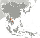
Southeastern Asia, northeast of Thailand, west of Vietnam Geographic coordinates
18 00 N, 105 00 E
Map references
Southeast Asia
Area World Ranking: 84
Total 236,800 sq km
Land 230,800 sq km Water 6,000 sq km Area - comparative
Slightly larger than Utah
Land boundaries
Total 5,083 km
Border countries Burma 235 km, Cambodia 541 km, China 423 km, Thailand 1,754 km, Vietnam 2,130 km Coastline
0 km (landlocked)
Maritime claims
None (landlocked)
Climate
Tropical monsoon; rainy season (May to November); dry season (December to April) Terrain
Mostly rugged mountains; some plains and plateaus Elevation extremes
Lowest point Mekong River 70 m
Highest point Phu Bia 2,817 m Natural resources
Timber, hydropower, gypsum, tin, gold, gemstones Land use
Arable land 4.01%
Permanent crops 0.34% Other 95.65% (2005) Irrigated land
3,000 sq km (2003)
Total renewable water resources
333.6 cu km (2003)
Freshwater withdrawal (domestic/industrial/agricultural)
Total 3 cu km/yr (4%/6%/90%)
Per capita 507 cu m/yr (2000) Natural hazards
Floods, droughts
Environment - current issues
Unexploded ordnance; deforestation; soil erosion; most of the population does not have access to potable water Environment - international agreements
Party to
Biodiversity, Climate Change, Climate Change-Kyoto Protocol, Desertification, Endangered Species, Environmental Modification, Law of the Sea, Ozone Layer Protection Signed, but not ratified None of the selected agreements Geography - note
Landlocked; most of the country is mountainous and thickly forested; the Mekong River forms a large part of the western boundary with Thailand
Comments
Add a new comment: |
Advertisement
Members area
Laos (Vientiane):
 
GPS points from Laos (Vientiane)
|
||||||||

 Modern-day Laos has its roots in the ancient Lao kingdom of Lan Xang, established in the 14th Century under King FA NGUM. For 300 years Lan Xang had influence reaching into present-day Cambodia and Thailand, as well as over all of what is now Laos. After centuries of gradual decline, Laos came under the domination of Siam (Thailand) from the late 18th century until the late 19th century when it became part of French Indochina. The Franco-Siamese Treaty of 1907 defined the current Lao border with Thailand. In 1975, the Communist Pathet Lao took control of the government ending a six-century-old monarchy and instituting a strict socialist regime closely aligned to Vietnam. A gradual, limited return to private enterprise and the liberalization of foreign investment laws began in 1988. Laos became a member of ASEAN in 1997.