|
|
Advertisements:
TransportationAirports World Ranking: 88
53 (2012)
Airports - with paved runways
Total 40
Over 3,047 m 10 2,438 to 3,047 m 12 1,524 to 2,437 m 9 914 to 1,523 m 6 Under 914 m 3 (2012) Airports - with unpaved runways
Total 13
1,524 to 2,437 m 3 914 to 1,523 m 8 Under 914 m 2 (2012) Heliports
5 (2012)
Pipelines
Condensate 26 km; gas 2,756 km; liquid petroleum gas 97 km; oil 3,441 km; refined products 4,090 km (2010) Railways World Ranking: 49
Total 3,505 km
Narrow gauge 3,505 km 1.067-m gauge (2008) Roadways World Ranking: 26
Total 193,200 km
Paved 28,980 km Unpaved 164,220 km (2004) Waterways World Ranking: 15
8,600 km (Niger and Benue rivers and smaller rivers and creeks) (2011) Merchant marine World Ranking: 54
Total 89
By type Cargo 2, chemical tanker 28, liquefied gas 1, passenger/cargo 1, petroleum tanker 56, specialized tanker 1 Foreign-owned 3 (India 1, UK 2)Registered in other countries 33 (Bahamas 2, Bermuda 11, Comoros 1, Italy 1, Liberia 4, North Korea 1, Panama 6, Seychelles 1, unknown 6) (2010) Ports and terminals
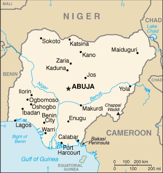
Bonny Inshore Terminal, Calabar, Lagos Transportation - note
The International Maritime Bureau reports the territorial and offshore waters in the Niger Delta and Gulf of Guinea as high risk for piracy and armed robbery against ships; in 2010, 19 commercial vessels were boarded or attacked with most occurring in the vicinity of the port of Lagos; crews were robbed and stores or cargoes stolen
Comments
Add a new comment: |
Advertisement
Members area
Nigeria (Abuja):
 
GPS points from Nigeria (Abuja)
|
||||||||

 British influence and control over what would become Nigeria and Africa's most populous country grew through the 19th century. A series of constitutions after World War II granted Nigeria greater autonomy; independence came in 1960. Following nearly 16 years of military rule, a new constitution was adopted in 1999, and a peaceful transition to civilian government was completed. The government continues to face the daunting task of reforming a petroleum-based economy, whose revenues have been squandered through corruption and mismanagement, and institutionalizing democracy. In addition, Nigeria continues to experience longstanding ethnic and religious tensions. Although both the 2003 and 2007 presidential elections were marred by significant irregularities and violence, Nigeria is currently experiencing its longest period of civilian rule since independence. The general elections of April 2007 marked the first civilian-to-civilian transfer of power in the country's history.