|
|
|
Advertisements:
GeographyLocation
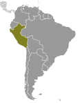
Western South America, bordering the South Pacific Ocean, between Chile and Ecuador Geographic coordinates
10 00 S, 76 00 W
Map references
South America
Area World Ranking: 20
Total 1,285,216 sq km
Land 1,279,996 sq km Water 5,220 sq km Area - comparative
Slightly smaller than Alaska
Land boundaries
Total 7,461 km
Border countries Bolivia 1,075 km, Brazil 2,995 km, Chile 171 km, Colombia 1,800 km, Ecuador 1,420 km Coastline
2,414 km
Maritime claims
Territorial sea 200 nm
Continental shelf 200 nm Climate
Varies from tropical in east to dry desert in west; temperate to frigid in Andes Terrain
Western coastal plain (costa), high and rugged Andes in center (sierra), eastern lowland jungle of Amazon Basin (selva) Elevation extremes
Lowest point Pacific Ocean 0 m
Highest point Nevado Huascaran 6,768 m Natural resources
Copper, silver, gold, petroleum, timber, fish, iron ore, coal, phosphate, potash, hydropower, natural gas Land use
Arable land 2.88%
Permanent crops 0.47% Other 96.65% (2005) Irrigated land
11,950 sq km (2003)
Total renewable water resources
1,913 cu km (2000)
Freshwater withdrawal (domestic/industrial/agricultural)
Total 20.13 cu km/yr (8%/10%/82%)
Per capita 720 cu m/yr (2000) Natural hazards
Earthquakes, tsunamis, flooding, landslides, mild volcanic activity Volcanism Volcanic activity in the Andes Mountains; Ubinas (elev. 5,672 m), which last erupted in 2009, is the country's most active volcano; other historically active volcanoes include El Misti, Huaynaputina, Sabancaya, and Yucamane Environment - current issues
Deforestation (some the result of illegal logging); overgrazing of the slopes of the costa and sierra leading to soil erosion; desertification; air pollution in Lima; pollution of rivers and coastal waters from municipal and mining wastes Environment - international agreements
Party to
Antarctic-Environmental Protocol, Antarctic-Marine Living Resources, Antarctic Treaty, Biodiversity, Climate Change, Climate Change-Kyoto Protocol, Desertification, Endangered Species, Hazardous Wastes, Marine Dumping, Ozone Layer Protection, Ship Pollution, Tropical Timber 83, Tropical Timber 94, Wetlands, Whaling Signed, but not ratified None of the selected agreements Geography - note
Shares control of Lago Titicaca, world's highest navigable lake, with Bolivia; a remote slope of Nevado Mismi, a 5,316 m peak, is the ultimate source of the Amazon River
Comments
Add a new comment: |
Advertisement
Members area
Peru (Lima):
 
GPS points from Peru (Lima)
|
||||||||

 Ancient Peru was the seat of several prominent Andean civilizations, most notably that of the Incas whose empire was captured by the Spanish conquistadors in 1533. Peruvian independence was declared in 1821, and remaining Spanish forces were defeated in 1824. After a dozen years of military rule, Peru returned to democratic leadership in 1980, but experienced economic problems and the growth of a violent insurgency. President Alberto FUJIMORI's election in 1990 ushered in a decade that saw a dramatic turnaround in the economy and significant progress in curtailing guerrilla activity. Nevertheless, the president's increasing reliance on authoritarian measures and an economic slump in the late 1990s generated mounting dissatisfaction with his regime, which led to his ouster in 2000. A caretaker government oversaw new elections in the spring of 2001, which ushered in Alejandro TOLEDO Manrique as the new head of government - Peru's first democratically elected president of Native American ethnicity. The presidential election of 2006 saw the return of Alan GARCIA Perez who, after a disappointing presidential term from 1985 to 1990, has overseen a robust macroeconomic performance. In June 2011, former army officer Ollanta HUMALA Tasso was elected president, defeating Keiko FUJIMORI Higuchi, the daughter of Alberto FUJIMORI. Since his election, HUMALA has carried on the sound, market-oriented economic policies of the three preceeding administrations.