|
|
|
Advertisements:
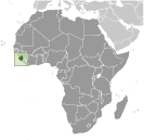
GeographyLocation
Western Africa, bordering the North Atlantic Ocean, between Guinea and Liberia Geographic coordinates
8 30 N, 11 30 W
Map references
Africa
Area World Ranking: 119
Total 71,740 sq km
Land 71,620 sq km Water 120 sq km Area - comparative
Slightly smaller than South Carolina Land boundaries
Total 958 km
Border countries Guinea 652 km, Liberia 306 km Coastline
402 km
Maritime claims
Territorial sea 12 nm
Contiguous zone 24 nm Exclusive economic zone 200 nm Continental shelf 200 nm Climate
Tropical; hot, humid; summer rainy season (May to December); winter dry season (December to April) Terrain
Coastal belt of mangrove swamps, wooded hill country, upland plateau, mountains in east Elevation extremes
Lowest point Atlantic Ocean 0 m
Highest point Loma Mansa (Bintimani) 1,948 m Natural resources
Diamonds, titanium ore, bauxite, iron ore, gold, chromite Land use
Arable land 7.95%
Permanent crops 1.05% Other 91% (2005) Irrigated land
300 sq km (2003)
Total renewable water resources
160 cu km (1987)
Freshwater withdrawal (domestic/industrial/agricultural)
Total 0.38 cu km/yr (5%/3%/92%)
Per capita 69 cu m/yr (2000) Natural hazards
Dry, sand-laden harmattan winds blow from the Sahara (December to February); sandstorms, dust storms Environment - current issues
Rapid population growth pressuring the environment; overharvesting of timber, expansion of cattle grazing, and slash-and-burn agriculture have resulted in deforestation and soil exhaustion; civil war depleted natural resources; overfishing Environment - international agreements
Party to
Biodiversity, Climate Change, Climate Change-Kyoto Protocol, Desertification, Endangered Species, Law of the Sea, Marine Life Conservation, Ozone Layer Protection, Ship Pollution, Wetlands Signed, but not ratified Environmental ModificationGeography - note
Rainfall along the coast can reach 495 cm (195 inches) a year, making it one of the wettest places along coastal, western Africa
Comments
Add a new comment: |
Advertisement
Members area
Sierra Leone (Freetown):
 
GPS points from Sierra Leone (Freetown)
|
||||||||

 Democracy is slowly being reestablished after the civil war from 1991 to 2002 that resulted in tens of thousands of deaths and the displacement of more than 2 million people (about a third of the population). The military, which took over full responsibility for security following the departure of UN peacekeepers at the end of 2005, is increasingly developing as a guarantor of the country's stability. The armed forces remained on the sideline during the 2007 presidential election but still look to the UN Integrated Office in Sierra Leone (UNIOSIL) - a civilian UN mission - to support efforts to consolidate peace. The new government's priorities include furthering development, creating jobs, and stamping out endemic corruption.