|
|
|
Advertisements:
GeographyLocation
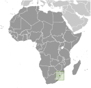
Southern Africa, between Mozambique and South Africa Geographic coordinates
26 30 S, 31 30 E
Map references
Africa
Area World Ranking: 159
Total 17,364 sq km
Land 17,204 sq km Water 160 sq km Area - comparative
Slightly smaller than New Jersey Land boundaries
Total 535 km
Border countries Mozambique 105 km, South Africa 430 km Coastline
0 km (landlocked)
Maritime claims
None (landlocked)
Climate
Varies from tropical to near temperate Terrain
Mostly mountains and hills; some moderately sloping plains Elevation extremes
Lowest point Great Usutu River 21 m
Highest point Emlembe 1,862 m Natural resources
Asbestos, coal, clay, cassiterite, hydropower, forests, small gold and diamond deposits, quarry stone, and talc Land use
Arable land 10.25%
Permanent crops 0.81% Other 88.94% (2005) Irrigated land
500 sq km (2003)
Total renewable water resources
4.5 cu km (1987)
Freshwater withdrawal (domestic/industrial/agricultural)
Total 1.04 cu km/yr (2%/1%/97%)
Per capita 1,010 cu m/yr (2000) Natural hazards
Drought
Environment - current issues
Limited supplies of potable water; wildlife populations being depleted because of excessive hunting; overgrazing; soil degradation; soil erosion Environment - international agreements
Party to
Biodiversity, Climate Change, Climate Change-Kyoto Protocol, Desertification, Endangered Species, Hazardous Wastes, Ozone Layer Protection Signed, but not ratified Law of the SeaGeography - note
Landlocked; almost completely surrounded by South Africa
Comments
Add a new comment: |
Advertisement
Members area
Swaziland (Mbabane):
 
GPS points from Swaziland (Mbabane)
|
||||||||

 Autonomy for the Swazis of southern Africa was guaranteed by the British in the late 19th century; independence was granted in 1968. Student and labor unrest during the 1990s pressured King MSWATI III, Africa's last absolute monarch, to grudgingly allow political reform and greater democracy, although he has backslid on these promises in recent years. A constitution came into effect in 2006, but the legal status of political parties remains unclear. The African United Democratic Party tried unsuccessfully to register as an official political party in mid 2006. Talks over the constitution broke down between the government and progressive groups in 2007. Swaziland recently surpassed Botswana as the country with the world's highest known HIV/AIDS prevalence rate.