|
|
|
Advertisements:
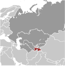
GeographyLocation
Central Asia, west of China, south of Kyrgyzstan Geographic coordinates
39 00 N, 71 00 E
Map references
Asia
Area World Ranking: 96
Total 143,100 sq km
Land 141,510 sq km Water 2,590 sq km Area - comparative
Slightly smaller than Wisconsin Land boundaries
Total 3,651 km
Border countries Afghanistan 1,206 km, China 414 km, Kyrgyzstan 870 km, Uzbekistan 1,161 km Coastline
0 km (landlocked)
Maritime claims
None (landlocked)
Climate
Midlatitude continental, hot summers, mild winters; semiarid to polar in Pamir Mountains Terrain
Pamir and Alay Mountains dominate landscape; western Fergana Valley in north, Kofarnihon and Vakhsh Valleys in southwest Elevation extremes
Lowest point Syr Darya (Sirdaryo) 300 m
Highest point Qullai Ismoili Somoni (Pik Imeni Ismail Samani) 7,495 m Natural resources
Hydropower, some petroleum, uranium, mercury, brown coal, lead, zinc, antimony, tungsten, silver, gold Land use
Arable land 6.52%
Permanent crops 0.89% Other 92.59% (2005) Irrigated land
7,220 sq km (2003)
Total renewable water resources
99.7 cu km (1997)
Freshwater withdrawal (domestic/industrial/agricultural)
Total 11.96 cu km/yr (4%/5%/92%)
Per capita 1,837 cu m/yr (2000) Natural hazards
Earthquakes; floods
Environment - current issues
Inadequate sanitation facilities; increasing levels of soil salinity; industrial pollution; excessive pesticides Environment - international agreements
Party to
Biodiversity, Climate Change, Climate Change-Kyoto Protocol, Desertification, Environmental Modification, Ozone Layer Protection, Wetlands Signed, but not ratified None of the selected agreements Geography - note
Landlocked; mountainous region dominated by the Trans-Alay Range in the north and the Pamirs in the southeast; highest point, Qullai Ismoili Somoni (formerly Communism Peak), was the tallest mountain in the former USSR
Comments
Add a new comment: |
Advertisement
Members area
Tajikistan (Dushanbe):
 
GPS points from Tajikistan (Dushanbe)
|
||||||||

 The Tajik people came under Russian rule in the 1860s and 1870s, but Russia's hold on Central Asia weakened following the Revolution of 1917. Bolshevik control of the area was fiercely contested and not fully reestablished until 1925. Much of present-day Sughd province was transferred from the Uzbek SSR to the newly formed Tajik SSR in 1929. Ethnic Uzbeks form a substantial minority in Tajikistan. Tajikistan became independent in 1991 following the breakup of the Soviet Union, and experienced a civil war between regional factions from 1992-97. Tajikistan experienced several security incidents in 2010, including a mass prison-break from a Dushanbe detention facility, the country's first suicide car bombing in Khujand, and armed conflict between government forces and opposition militants in the Rasht Valley. The country remains the poorest in the former Soviet sphere. Attention by the international community since the beginning of the NATO intervention in Afghanistan has brought increased economic development and security assistance, which could create jobs and strengthen stability in the long term. Tajikistan is seeking WTO membership and joined NATO's Partnership for Peace in 2002.