|
|
|
Advertisements:
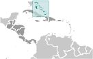
GeographyLocation
Chain of islands in the North Atlantic Ocean, southeast of Florida, northeast of Cuba Geographic coordinates
24 15 N, 76 00 W
Map references
Central America and the Caribbean
Area World Ranking: 161
Total 13,880 sq km
Land 10,010 sq km Water 3,870 sq km Area - comparative
Slightly smaller than Connecticut Land boundaries
0 km
Coastline
3,542 km
Maritime claims
Territorial sea 12 nm
Exclusive economic zone 200 nm Climate
Tropical marine; moderated by warm waters of Gulf Stream Terrain
Long, flat coral formations with some low rounded hills Elevation extremes
Lowest point Atlantic Ocean 0 m
Highest point Mount Alvernia on Cat Island 63 m Natural resources
Salt, aragonite, timber, arable land Land use
Arable land 0.58%
Permanent crops 0.29% Other 99.13% (2005) Irrigated land
10 sq km (2003)
Total renewable water resources
NA
Natural hazards
Hurricanes and other tropical storms cause extensive flood and wind damage Environment - current issues
Coral reef decay; solid waste disposal Environment - international agreements
Party to
Biodiversity, Climate Change, Climate Change-Kyoto Protocol, Desertification, Endangered Species, Hazardous Wastes, Law of the Sea, Ozone Layer Protection, Ship Pollution, Wetlands Signed, but not ratified None of the selected agreements Geography - note
Strategic location adjacent to US and Cuba; extensive island chain of which 30 are inhabited
Comments
Add a new comment: |
Advertisement
Members area
The Bahamas (Nassau):
 
GPS points from The Bahamas (Nassau)
|
||||||||

 Lucayan Indians inhabited the islands when Christopher COLUMBUS first set foot in the New World on San Salvador in 1492. British settlement of the islands began in 1647; the islands became a colony in 1783. Since attaining independence from the UK in 1973, The Bahamas has prospered through tourism and international banking and investment management. Because of its geography, the country is a major transshipment point for illegal drugs, particularly shipments to the US and Europe, and its territory is used for smuggling illegal migrants into the US.