|
|
|
Advertisements:
GeographyLocation
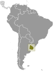
Southern South America, bordering the South Atlantic Ocean, between Argentina and Brazil Geographic coordinates
33 00 S, 56 00 W
Map references
South America
Area World Ranking: 91
Total 176,215 sq km
Land 175,015 sq km Water 1,200 sq km Area - comparative
Slightly smaller than the state of Washington Land boundaries
Total 1,648 km
Border countries Argentina 580 km, Brazil 1,068 km Coastline
660 km
Maritime claims
Territorial sea 12 nm
Contiguous zone 24 nm Exclusive economic zone 200 nm Continental shelf 200 nm or edge of continental margin Climate
Warm temperate; freezing temperatures almost unknown Terrain
Mostly rolling plains and low hills; fertile coastal lowland Elevation extremes
Lowest point Atlantic Ocean 0 m
Highest point Cerro Catedral 514 m Natural resources
Arable land, hydropower, minor minerals, fish Land use
Arable land 7.77%
Permanent crops 0.24% Other 91.99% (2005) Irrigated land
2,180 sq km (2003)
Total renewable water resources
139 cu km (2000)
Freshwater withdrawal (domestic/industrial/agricultural)
Total 3.15 cu km/yr (2%/1%/96%)
Per capita 910 cu m/yr (2000) Natural hazards
Seasonally high winds (the pampero is a chilly and occasional violent wind that blows north from the Argentine pampas), droughts, floods; because of the absence of mountains, which act as weather barriers, all locations are particularly vulnerable to rapid changes from weather fronts Environment - current issues
Water pollution from meat packing/tannery industry; inadequate solid/hazardous waste disposal Environment - international agreements
Party to
Antarctic-Environmental Protocol, Antarctic-Marine Living Resources, Antarctic Treaty, Biodiversity, Climate Change, Climate Change-Kyoto Protocol, Desertification, Endangered Species, Environmental Modification, Hazardous Wastes, Law of the Sea, Ozone Layer Protection, Ship Pollution, Wetlands Signed, but not ratified Marine Dumping, Marine Life Conservation Geography - note
Second-smallest South American country (after Suriname); most of the low-lying landscape (three-quarters of the country) is grassland, ideal for cattle and sheep raising
Comments
Add a new comment: |
Advertisement
Members area
Uruguay (Montevideo):
 
GPS points from Uruguay (Montevideo)
|
||||||||

 Montevideo, founded by the Spanish in 1726 as a military stronghold, soon took advantage of its natural harbor to become an important commercial center. Claimed by Argentina but annexed by Brazil in 1821, Uruguay declared its independence four years later and secured its freedom in 1828 after a three-year struggle. The administrations of President Jose BATLLE in the early 20th century established widespread political, social, and economic reforms that established a statist tradition. A violent Marxist urban guerrilla movement named the Tupamaros, launched in the late 1960s, led Uruguay's president to cede control of the government to the military in 1973. By yearend, the rebels had been crushed, but the military continued to expand its hold over the government. Civilian rule was not restored until 1985. In 2004, the left-of-center Frente Amplio Coalition won national elections that effectively ended 170 years of political control previously held by the Colorado and Blanco parties. Uruguay's political and labor conditions are among the freest on the continent.