|
|
Advertisements:
GovernmentCountry name
Conventional long form Republic of Zimbabwe
Conventional short form Zimbabwe Former Southern Rhodesia, Rhodesia Government type
Parliamentary democracy
Capital
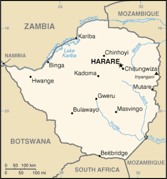
Name Harare
Geographic coordinates 17 49 S, 31 02 E Time difference UTC+2 (7 hours ahead of Washington, DC during Standard Time) Administrative divisions
8 provinces and 2 cities* with provincial status; Bulawayo*, Harare*, Manicaland, Mashonaland Central, Mashonaland East, Mashonaland West, Masvingo, Matabeleland North, Matabeleland South, Midlands Independence
18 April 1980 (from the UK)
Constitution
21 December 1979
Legal system
Mixed legal system of English common law, Roman-Dutch civil law, and customary law International law organization participation
Has not submitted an ICJ jurisdiction declaration; non-party state to the ICCt Suffrage
18 years of age; universal
Executive branch
Chief of state
Executive President Robert Gabriel MUGABE (since 31 December 1987); Vice President John NKOMO (since December 2009) and Vice President Joice MUJURU (since 6 December 2004) Head of government Prime Minister Morgan TSVANGIRAI (since 11 February 2009); Deputy Prime Minister Arthur MUTAMBARA Cabinet Cabinet appointed by the president and prime minister; responsible to the House of Assembly Elections Presidential candidates nominated with a nomination paper signed by at least 10 registered voters (at least one from each province) and elected by popular vote for a five-year term (no term limits); elections last held on 28 March 2008 followed by a run-off on 27 June 2008 (next to be held in 2013); co-vice presidents drawn from party leadership Election results Robert Gabriel MUGABE reelected president; percent of vote - Robert Gabriel MUGABE 85.5%, Morgan TSVANGIRAI 9.3%, other 5.2%; note - first round voting results - Morgan TSVANGIRAI 47.9%, Robert Gabriel MUGABE 43.2%, Simba MAKONI 8.3%, other 0.6%; first-round round polls were deemed to be flawed suppressing TSVANGIRAI's results; the 27 June 2008 run-off between MUGABE and TSVANGIRAI was severely flawed and internationally condemned Legislative branch
Bicameral Parliament consists of a Senate (93 seats - 60 members elected by popular vote for a five-year term, 10 provincial governors nominated by the president and the prime minister, 16 traditional chiefs elected by the Council of Chiefs, 2 seats held by the president and deputy president of the Council of Chiefs, and 5 members appointed by the president) and a House of Assembly (210 seats - members elected by popular vote for five-year terms) Elections Last held on 28 March 2008 (next to be held in 2013) Election results Senate - percent of vote by party - MDC 51.6%, ZANU-PF 45.8%, other 2.6%; seats by party - MDC 30, ZANU-PF 30; House of Assembly - percent of vote by party - MDC 51.3%, ZANU-PF 45.8%, other 2.9%; seats by party - MDC 109, ZANU-PF 97, other 4 Judicial branch
Supreme Court; High Court
Political parties and leaders
African National Party or ANP [Egypt DZINEMUNHENZVA]; Movement for Democratic Change or MDC [Morgan TSVANGIRAI]; Movement for Democratic Change - Ncube or MDC-N [Welshman NCUBE]; Peace Action is Freedom for All or PAFA; United Parties [Abel MUZOREWA]; United People's Party or UPP [Daniel SHUMBA]; Zimbabwe African National Union-Ndonga or ZANU-Ndonga [Wilson KUMBULA]; Zimbabwe African National Union-Patriotic Front or ZANU-PF [Robert Gabriel MUGABE]; Zimbabwe African Peoples Union or ZAPU [Agrippa MADLELA]; Zimbabwe Youth in Alliance or ZIYA Political pressure groups and leaders
Crisis in Zimbabwe Coalition; National Constitutional Assembly or NCA [Lovemore MADHUKU]; Women of Zimbabwe Arise or WOZA [Jenny WILLIAMS]; Zimbabwe Congress of Trade Unions or ZCTU [Wellington CHIBEBE] International organization participation
ACP, AfDB, AU, COMESA, FAO, G-15, G-77, IAEA, IBRD, ICAO, ICRM, IDA, IFAD, IFC, IFRCS, ILO, IMF, IMO, Interpol, IOC, IOM, IPU, ISO, ITSO, ITU, ITUC, MIGA, NAM, OPCW, PCA, SADC, UN, UNAMID, UNCTAD, UNESCO, UNIDO, UNMIL, UNOCI, UNWTO, UPU, WCO, WFTU, WHO, WIPO, WMO, WTO Diplomatic representation in the us
Chief of mission
Ambassador Machivenyika MAPURANGA Chancery 1608 New Hampshire Avenue NW, Washington, DC 20009 Telephone [1] (202) 332-7100FAX [1] (202) 483-9326 Diplomatic representation from the us
Chief of mission Ambassador Charles A. RAY
Embassy 172 Herbert Chitepo Avenue, Harare Mailing address P. O. Box 3340, HarareTelephone [263] (4) 250-593 through 250-594 FAX [263] (4) 796-488, or 722-618Flag description
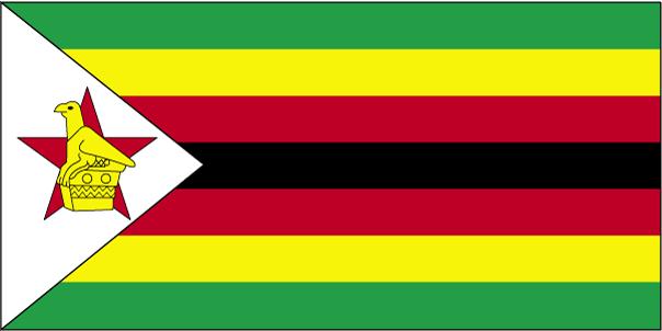
Seven equal horizontal bands of green, yellow, red, black, red, yellow, and green with a white isosceles triangle edged in black with its base on the hoist side; a yellow Zimbabwe bird representing the long history of the country is superimposed on a red five-pointed star in the center of the triangle, which symbolizes peace; green represents agriculture, yellow mineral wealth, red the blood shed to achieve independence, and black stands for the native people National symbol(s)
Zimbabwe bird symbol; African fish eagle National anthem
Name
"Kalibusiswe Ilizwe leZimbabwe" [Northern Ndebele language] "Simudzai Mureza WeZimbabwe" [Shona] (Blessed Be the Land of Zimbabwe) Lyrics/music Solomon MUTSWAIRO/Fred Lecture CHANGUNDEGA Note Adopted 1994
Comments
Add a new comment: |
Advertisement
Members area
Zimbabwe (Harare):
 
GPS points from Zimbabwe (Harare)
|
||||||||

 The UK annexed Southern Rhodesia from the [British] South Africa Company in 1923. A 1961 constitution was formulated that favored whites in power. In 1965 the government unilaterally declared its independence, but the UK did not recognize the act and demanded more complete voting rights for the black African majority in the country (then called Rhodesia). UN sanctions and a guerrilla uprising finally led to free elections in 1979 and independence (as Zimbabwe) in 1980. Robert MUGABE, the nation's first prime minister, has been the country's only ruler (as president since 1987) and has dominated the country's political system since independence. His chaotic land redistribution campaign, which began in 2000, caused an exodus of white farmers, crippled the economy, and ushered in widespread shortages of basic commodities. Ignoring international condemnation, MUGABE rigged the 2002 presidential election to ensure his reelection. In April 2005, Harare embarked on Operation Restore Order, ostensibly an urban rationalization program, which resulted in the destruction of the homes or businesses of 700,000 mostly poor supporters of the opposition. President MUGABE in June 2007 instituted price controls on all basic commodities causing panic buying and leaving store shelves empty for months.