|
|
|
Weather Gegham Lerrnagagat' (Cloud cover, Temperature, Wind speed and Precipitation mm probab.)
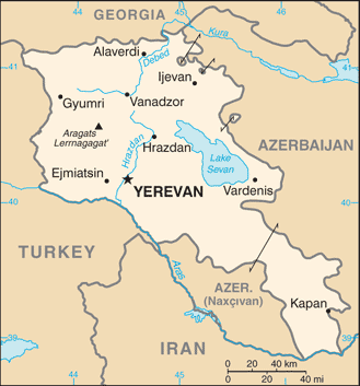
Map and Photos Gegham Lerrnagagat'
Comments
Add a new comment: |
Members area
Armenia (Yerevan):
Advertisement
GPS points near Gegham Lerrnagagat'
 Ozero Akha (2 km)
Ozero Akna (2 km)
Akna Lich (2 km)
Ozero Aknalich (2 km)
Ozero Kanchgel' (2 km)
Ozero Kanly-Gel' (2 km)
Gora Kara-Chengil (4 km)
Gora Karaganchal (4 km)
Gora Azhdaak (6 km)
Azhdahak Lerr (6 km)
Kysyl-Dag (6 km)
Gora Kyzyl-Dag (6 km)
Karakala (7 km)
Sevaberd (7 km)
Gora Kara-Dag (8 km)
Gora Sevkatar (8 km)
Mount Sevkatar (8 km)
Ozero Akha (2 km)
Ozero Akna (2 km)
Akna Lich (2 km)
Ozero Aknalich (2 km)
Ozero Kanchgel' (2 km)
Ozero Kanly-Gel' (2 km)
Gora Kara-Chengil (4 km)
Gora Karaganchal (4 km)
Gora Azhdaak (6 km)
Azhdahak Lerr (6 km)
Kysyl-Dag (6 km)
Gora Kyzyl-Dag (6 km)
Karakala (7 km)
Sevaberd (7 km)
Gora Kara-Dag (8 km)
Gora Sevkatar (8 km)
Mount Sevkatar (8 km)
GPS points from Armenia (Yerevan)
|