|
|
|
Weather Naryshtdere (Cloud cover, Temperature, Wind speed and Precipitation mm probab.)
Map and Photos Naryshtdere
Comments
Add a new comment: |
Members area
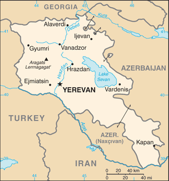
Armenia (Yerevan):
Advertisement
GPS points near Naryshtdere
 Dian (0.5km)
Agdzhakala (1 km)
Nerkin Agdzhakala (1 km)
Nerkin Bazmaberd (1 km)
Nizhnyaya Agdzhakala (1 km)
Baysuz (1 km)
Baysyz (1 km)
Agarak (1 km)
Karadzhalar (3 km)
Sasunik (3 km)
Avtona (3 km)
Schanlu (3 km)
Lernarot (4 km)
Magda (4 km)
Verin Agdzhakala (4 km)
Verin Bazmaberd (4 km)
Verkhnyaya Agdzhakala (4 km)
Dian (0.5km)
Agdzhakala (1 km)
Nerkin Agdzhakala (1 km)
Nerkin Bazmaberd (1 km)
Nizhnyaya Agdzhakala (1 km)
Baysuz (1 km)
Baysyz (1 km)
Agarak (1 km)
Karadzhalar (3 km)
Sasunik (3 km)
Avtona (3 km)
Schanlu (3 km)
Lernarot (4 km)
Magda (4 km)
Verin Agdzhakala (4 km)
Verin Bazmaberd (4 km)
Verkhnyaya Agdzhakala (4 km)
GPS points from Armenia (Yerevan)
|