|
|
|
|
|
|
|
viewweather.com
sv.ViewWeather.com fr.ViewWeather.com da.ViewWeather.com de.ViewWeather.com es.ViewWeather.com |
www.carpati.org www.searchromania.net Deblocari usi |
es.getamap.org fr.getamap.org de.getamap.org nl.getamap.org da.getamap.org www.getamap.org |
Links
Terms of use Privacy policy # 0.0226 sec |
contact AT getamap.net © 2006 - 2024 https://www.getamap.net/ |


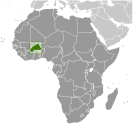 Burkina Faso (formerly Upper Volta) achieved independence from France in 1960. Repeated military coups during the 1970s and 1980s were followed by multiparty elections in the early 1990s. Current President Blaise COMPAORE came to power in a 1987 military coup and has won every election since then. Burkina Faso's high population density and limited natural resources result in poor economic prospects for the majority of its citizens.
