|
|
|
Advertisements:
GeographyLocation
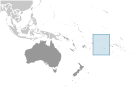
Oceania, group of islands in the South Pacific Ocean, about half way between Hawaii and New Zealand Geographic coordinates
21 14 S, 159 46 W
Map references
Oceania
Area World Ranking: 214
Total 236 sq km
Land 236 sq km Water 0 sq km Area - comparative
1.3 times the size of Washington, DC Land boundaries
0 km
Coastline
120 km
Maritime claims
Territorial sea 12 nm
Exclusive economic zone 200 nm Continental shelf 200 nm or to the edge of the continental margin Climate
Tropical oceanic; moderated by trade winds; a dry season from April to November and a more humid season from December to March Terrain
Low coral atolls in north; volcanic, hilly islands in south Elevation extremes
Lowest point Pacific Ocean 0 m
Highest point Te Manga 652 m Natural resources
NEGL
Land use
Arable land 16.67%
Permanent crops 8.33% Other 75% (2005) Irrigated land
NA
Natural hazards
Typhoons (November to March)
Environment - current issues
NA
Environment - international agreements
Party to
Biodiversity, Climate Change, Climate Change-Kyoto Protocol, Desertification, Hazardous Wastes, Law of the Sea, Ozone Layer Protection Geography - note
The northern Cook Islands are seven low-lying, sparsely populated, coral atolls; the southern Cook Islands, where most of the population lives, consist of eight elevated, fertile, volcanic isles, including the largest, Rarotonga, at 67 sq km
Comments
Add a new comment: |
Advertisement
Members area
Cook Islands [ New Zealand ] (Free Association):
 
GPS points from Cook Islands [ New Zealand ] (Free Association)
|
||||||||

 Named after Captain COOK, who sighted them in 1770, the islands became a British protectorate in 1888. By 1900, administrative control was transferred to New Zealand; in 1965, residents chose self-government in free association with New Zealand. The emigration of skilled workers to New Zealand and government deficits are continuing problems.