|
|
|
Advertisements:
GeographyLocation
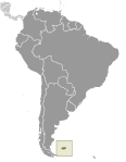
Southern South America, islands in the South Atlantic Ocean, east of southern Argentina Geographic coordinates
51 45 S, 59 00 W
Map references
South America
Area World Ranking: 165
Total 12,173 sq km
Land 12,173 sq km Water 0 sq km Note Includes the two main islands of East and West Falkland and about 200 small islands Area - comparative
Slightly smaller than Connecticut Land boundaries
0 km
Coastline
1,288 km
Maritime claims
Territorial sea 12 nm
Continental shelf 200 nm Exclusive fishing zone 200 nm Climate
Cold marine; strong westerly winds, cloudy, humid; rain occurs on more than half of days in year; average annual rainfall is 24 inches in Stanley; occasional snow all year, except in January and February, but typically does not accumulate Terrain
Rocky, hilly, mountainous with some boggy, undulating plains Elevation extremes
Lowest point Atlantic Ocean 0 m
Highest point Mount Usborne 705 m Natural resources
Fish, squid, wildlife, calcified seaweed, sphagnum moss Land use
Arable land 0%
Permanent crops 0% Other 100% (99% permanent pastures, 1% other) (2005) Irrigated land
NA
Natural hazards
Strong winds persist throughout the year Environment - current issues
Overfishing by unlicensed vessels is a problem; reindeer were introduced to the islands in 2001 for commercial reasons; this is the only commercial reindeer herd in the world unaffected by the 1986 Chornobyl disaster Geography - note
Deeply indented coast provides good natural harbors; short growing season
Comments
Add a new comment: |
Advertisement
Members area
Falkland Islands ( Islas Malvinas ) [ United Kingdom ] (Overseas Territory):
 
GPS points from Falkland Islands ( Islas Malvinas ) [ United Kingdom ] (Overseas Territory)
|
||||||||

 Although first sighted by an English navigator in 1592, the first landing (English) did not occur until almost a century later in 1690, and the first settlement (French) was not established until 1764. The colony was turned over to Spain two years later and the islands have since been the subject of a territorial dispute, first between Britain and Spain, then between Britain and Argentina. The UK asserted its claim to the islands by establishing a naval garrison there in 1833. Argentina invaded the islands on 2 April 1982. The British responded with an expeditionary force that landed seven weeks later and after fierce fighting forced an Argentine surrender on 14 June 1982. With hostilities ended and Argentine forces withdrawn, UK administration resumed.