|
|
Advertisements:
GovernmentCountry name
Conventional long form None
Conventional short form Jamaica Government type
Constitutional parliamentary democracy and a Commonwealth realm Capital
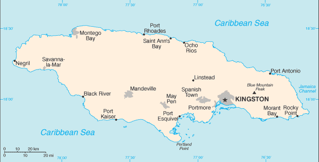
Name Kingston
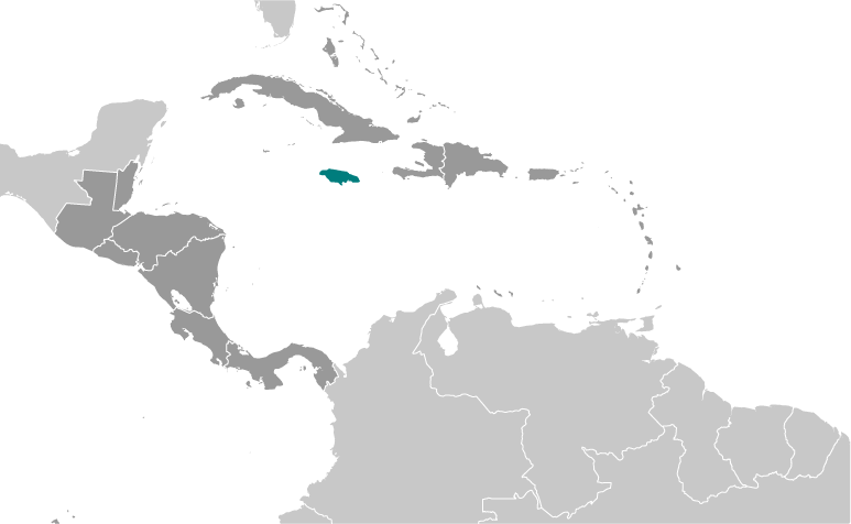
Geographic coordinates 18 00 N, 76 48 W Time difference UTC-5 (same time as Washington, DC during Standard Time) Administrative divisions
14 parishes; Clarendon, Hanover, Kingston, Manchester, Portland, Saint Andrew, Saint Ann, Saint Catherine, Saint Elizabeth, Saint James, Saint Mary, Saint Thomas, Trelawny, Westmoreland Note For local government purposes, Kingston and Saint Andrew were amalgamated in 1923 into the present single corporate body known as the Kingston and Saint Andrew Corporation Independence
6 August 1962 (from the UK)
National holiday
Independence Day, 6 August (1962) Constitution
6 August 1962
Legal system
Common law system based on the English model International law organization participation
Has not submitted an ICJ jurisdiction declaration; non-party state to the ICCt Suffrage
18 years of age; universal
Executive branch
Chief of state
Queen ELIZABETH II (since 6 February 1952); represented by Governor General Dr. Patrick L. ALLEN (since 26 February 2009) Head of government Prime Minister Portia SIMPSON-MILLER (since 5 January 2012) Cabinet Cabinet is appointed by the governor general on the advice of the prime minister Elections The monarchy is hereditary; governor general appointed by the monarch on the recommendation of the prime minister; following legislative elections, the leader of the majority party or the leader of the majority coalition in the House of Representatives is appointed prime minister by the governor general Legislative branch
Bicameral Parliament consists of the Senate (a 21-member body appointed by the governor general on the recommendations of the prime minister and the leader of the opposition; ruling party is allocated 13 seats, and the opposition is allocated 8 seats) and the House of Representatives (63 seats; members elected by popular vote to serve five-year terms) Elections Last held on 29 December 2011 (next to be held no later than December 2016) Election results Percent of vote by party - PNP 53.3%, JLP 46.6%; seats by party - PNP 42, JLP 21 Judicial branch
Supreme Court (judges appointed by the governor general on the advice of the prime minister); Court of Appeal; Privy Council in UK; member of the Caribbean Court of Justice (CCJ) Political parties and leaders
Jamaica Labor Party or JLP [Andrew HOLNESS]; People's National Party or PNP [Portia SIMPSON-MILLER]; National Democratic Movement or NDM [Michael WILLIAMS] Political pressure groups and leaders
New Beginnings Movement or NBM; Rastafarians (black religious/racial cultists, pan-Africanists) International organization participation
ACP, AOSIS, C, Caricom, CDB, CELAC, FAO, G-15, G-77, IADB, IAEA, IBRD, ICAO, ICRM, IFAD, IFC, IFRCS, IHO, ILO, IMF, IMO, Interpol, IOC, IOM, ISO, ITSO, ITU, LAES, MIGA, NAM, OAS, OPANAL, OPCW, Petrocaribe, UN, UNCTAD, UNESCO, UNIDO, UNITAR, UNWTO, UPU, WCO, WFTU, WHO, WIPO, WMO, WTO Diplomatic representation in the us
Chief of mission Ambassador Stephen VASCIANNIE
Chancery 1520 New Hampshire Avenue NW, Washington, DC 20036 Telephone [1] (202) 452-0660FAX [1] (202) 452-0081 Consulate(s) general Miami, New York Diplomatic representation from the us
Chief of mission Ambassador Pamela BRIDGEWATER
Embassy 142 Old Hope Road, Kingston 6 Mailing address P.O. Box 541, Kingston 5 Telephone [1] (876) 702-6000 FAX [1] (876) 702-6001 Flag description
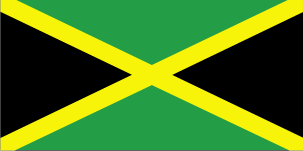
Diagonal yellow cross divides the flag into four triangles - green (top and bottom) and black (hoist side and outer side); green represents hope, vegetation, and agriculture, black reflects hardships overcome and to be faced, and yellow recalls golden sunshine and the island's natural resources National symbol(s)
Green-and-black streamertail (bird) National anthem
Name "Jamaica, Land We Love"
Lyrics/music Hugh Braham SHERLOCK/Robert Charles LIGHTBOURNE Note Adopted 1962
Comments
Add a new comment: |
Advertisement
Members area
Jamaica (Kingston):
 
GPS points from Jamaica (Kingston)
|
||||||||

 The island - discovered by Christopher COLUMBUS in 1494 - was settled by the Spanish early in the 16th century. The native Taino Indians, who had inhabited Jamaica for centuries, were gradually exterminated and replaced by African slaves. England seized the island in 1655 and established a plantation economy based on sugar, cocoa, and coffee. The abolition of slavery in 1834 freed a quarter million slaves, many of whom became small farmers. Jamaica gradually increased its independence from Britain. In 1958 it joined other British Caribbean colonies in forming the Federation of the West Indies. Jamaica gained full independence when it withdrew from the Federation in 1962. Deteriorating economic conditions during the 1970s led to recurrent violence as rival gangs affiliated with the major political parties evolved into powerful organized crime networks involved in international drug smuggling and money laundering. Violent crime, drug trafficking, and poverty pose significant challenges to the government today. Nonetheless, many rural and resort areas remain relatively safe and contribute substantially to the economy.