|
|
|
Advertisements:
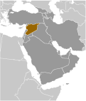
GeographyLocation
Middle East, bordering the Mediterranean Sea, between Lebanon and Turkey Geographic coordinates
35 00 N, 38 00 E
Map references
Middle East
Area World Ranking: 89
Total 185,180 sq km
Land 183,630 sq km Water 1,550 sq km Note Includes 1,295 sq km of Israeli-occupied territory Area - comparative
Slightly larger than North Dakota Land boundaries
Total 2,253 km
Border countries Iraq 605 km, Israel 76 km, Jordan 375 km, Lebanon 375 km, Turkey 822 km Coastline
193 km
Maritime claims
Territorial sea 12 nm
Contiguous zone 24 nm Climate
Mostly desert; hot, dry, sunny summers (June to August) and mild, rainy winters (December to February) along coast; cold weather with snow or sleet periodically in Damascus Terrain
Primarily semiarid and desert plateau; narrow coastal plain; mountains in west Elevation extremes
Lowest point
Unnamed location near Lake Tiberias -200 m Highest point Mount Hermon 2,814 mNatural resources
Petroleum, phosphates, chrome and manganese ores, asphalt, iron ore, rock salt, marble, gypsum, hydropower Land use
Arable land 24.8%
Permanent crops 4.47% Other 70.73% (2005) Irrigated land
13,560 sq km (2003)
Total renewable water resources
46.1 cu km (1997)
Freshwater withdrawal (domestic/industrial/agricultural)
Total 19.95 cu km/yr (3%/2%/95%)
Per capita 1,048 cu m/yr (2000) Natural hazards
Dust storms, sandstorms
Volcanism Syria's two historically active volcanoes, Es Safa and an unnamed volcano near the Turkish border have not erupted in centuries Environment - current issues
Deforestation; overgrazing; soil erosion; desertification; water pollution from raw sewage and petroleum refining wastes; inadequate potable water Environment - international agreements
Party to
Biodiversity, Climate Change, Climate Change-Kyoto Protocol, Desertification, Endangered Species, Hazardous Wastes, Ozone Layer Protection, Ship Pollution, Wetlands Signed, but not ratified Environmental ModificationGeography - note
The capital of Damascus - located at an oasis fed by the Barada River - is thought to be one of the world's oldest continuously inhabited cities; there are 41 Israeli settlements and civilian land use sites in the Israeli-occupied Golan Heights (2010 est.)
Comments
Add a new comment: |
Advertisement
Members area
Syria (Damascus):
 
GPS points from Syria (Damascus)
|
||||||||

 Following World War I, France acquired a mandate over the northern portion of the former Ottoman Empire province of Syria. The French administered the area as Syria until granting it independence in 1946. The new country lacked political stability, however, and experienced a series of military coups during its first decades. Syria united with Egypt in February 1958 to form the United Arab Republic. In September 1961, the two entities separated, and the Syrian Arab Republic was reestablished. In November 1970, Hafiz al-ASAD, a member of the Socialist Ba'th Party and the minority Alawi sect, seized power in a bloodless coup and brought political stability to the country. In the 1967 Arab-Israeli War, Syria lost the Golan Heights to Israel. During the 1990s, Syria and Israel held occasional peace talks over its return. Following the death of President al-ASAD, his son, Bashar al-ASAD, was approved as president by popular referendum in July 2000. Syrian troops - stationed in Lebanon since 1976 in an ostensible peacekeeping role - were withdrawn in April 2005. During the July-August 2006 conflict between Israel and Hizballah, Syria placed its military forces on alert but did not intervene directly on behalf of its ally Hizballah. In May 2007 Bashar al-ASAD was elected to his second term as president.