|
|
Advertisements:
GeographyLocation
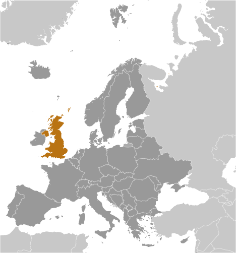
Western Europe, islands - including the northern one-sixth of the island of Ireland - between the North Atlantic Ocean and the North Sea; northwest of France Geographic coordinates
54 00 N, 2 00 W
Map references
Europe
Area World Ranking: 80
Total 243,610 sq km
Land 241,930 sq km Water 1,680 sq km Note Includes Rockall and Shetland Islands Area - comparative
Slightly smaller than Oregon
Land boundaries
Total 360 km
Border countries Ireland 360 km Coastline
12,429 km
Maritime claims
Territorial sea 12 nm
Exclusive fishing zone 200 nm Continental shelf As defined in continental shelf orders or in accordance with agreed upon boundaries Climate
Temperate; moderated by prevailing southwest winds over the North Atlantic Current; more than one-half of the days are overcast Terrain
Mostly rugged hills and low mountains; level to rolling plains in east and southeast Elevation extremes
Lowest point The Fens -4 m
Highest point Ben Nevis 1,343 m Natural resources
Coal, petroleum, natural gas, iron ore, lead, zinc, gold, tin, limestone, salt, clay, chalk, gypsum, potash, silica sand, slate, arable land Land use
Arable land 23.23%
Permanent crops 0.2% Other 76.57% (2005) Irrigated land
1,950 sq km (2003)
Total renewable water resources
160.6 cu km (2005)
Freshwater withdrawal (domestic/industrial/agricultural)
Total 11.75 cu km/yr (22%/75%/3%)
Per capita 197 cu m/yr (1994) Natural hazards
Winter windstorms; floods
Environment - current issues
Continues to reduce greenhouse gas emissions (has met Kyoto Protocol target of a 12.5% reduction from 1990 levels and intends to meet the legally binding target and move toward a domestic goal of a 20% cut in emissions by 2010); by 2005 the government reduced the amount of industrial and commercial waste disposed of in landfill sites to 85% of 1998 levels and recycled or composted at least 25% of household waste, increasing to 33% by 2015 Environment - international agreements
Party to
Air Pollution, Air Pollution-Nitrogen Oxides, Air Pollution-Persistent Organic Pollutants, Air Pollution-Sulfur 94, Air Pollution-Volatile Organic Compounds, Antarctic-Environmental Protocol, Antarctic-Marine Living Resources, Antarctic Seals, Antarctic Treaty, Biodiversity, Climate Change, Climate Change-Kyoto Protocol, Desertification, Endangered Species, Environmental Modification, Hazardous Wastes, Law of the Sea, Marine Dumping, Marine Life Conservation, Ozone Layer Protection, Ship Pollution, Tropical Timber 83, Tropical Timber 94, Wetlands, Whaling Signed, but not ratified None of the selected agreements Geography - note
Lies near vital North Atlantic sea lanes; only 35 km from France and linked by tunnel under the English Channel; because of heavily indented coastline, no location is more than 125 km from tidal waters
Comments
Add a new comment: |
Advertisement
Members area
United Kingdom (London):
 
GPS points from United Kingdom (London)
|
||||||||

 The United Kingdom has historically played a leading role in developing parliamentary democracy and in advancing literature and science. At its zenith in the 19th century, the British Empire stretched over one-fourth of the earth's surface. The first half of the 20th century saw the UK's strength seriously depleted in two world wars and the Irish Republic's withdrawal from the union. The second half witnessed the dismantling of the Empire and the UK rebuilding itself into a modern and prosperous European nation. As one of five permanent members of the UN Security Council and a founding member of NATO and the Commonwealth, the UK pursues a global approach to foreign policy. The UK is also an active member of the EU, although it chose to remain outside the Economic and Monetary Union. The Scottish Parliament, the National Assembly for Wales, and the Northern Ireland Assembly were established in 1999. The latter was suspended until May 2007 due to wrangling over the peace process, but devolution was fully completed in March 2010.