English   Română   Español   Français   Deutsch  

getamap.net

Africa

Oceania

Asia

North America

Europe

South America

Antarctica


Planell de Laverdú

(Coma de Varilles) / Andorra (general)

42°37'60" N
1°31'60" E
~2,072m asl
11:49 (CEST - UTC/GMT+2)

Planell de Laverdu (Planell de Laverdú) is a upland (class T - Hypsographic) in Andorra (general), Andorra (Europe) with the region font code of Americas/Western Europe. It is located at an elevation of 2,072 meters above sea level.

Its coordinates are 42°37'60" N and 1°31'60" E in DMS (Degrees Minutes Seconds) or 42.6333 and 1.53333 (in decimal degrees). Its UTM position is CH72 and its Joint Operation Graphics reference is NK31-04.

Current local time is 11:49; the sun rises at 07:53 and sets at 20:00 local time (Europe/Andorra UTC/GMT+2). The standard time zone for Planell de Laverdu is UTC/GMT+1, but since Daylight Saving Time (DST) is in effect the current time zone is UTC/GMT+2.
In 2024 DST starts on 31 Mar 2024 and ends on 27 Oct 2024.

A Upland is an extensive interior region of high land with low to moderate surface relief.


Country
 Advertisements:


 Advertisements:


Weather Planell de Laverdú (Cloud cover, Temperature, Wind speed and Precipitation mm probab.)

Mon


Apr 29
Clound 20-100-100-100 Mist
~34 l/m2 97%
 
20-34 cm (Snow)
-6 °C min
-4 °C max
7 km/h
Thu Jan 1

Tue


Apr 30
Clound 30-90-30-40 Mist
~6 l/m2 66%
 
3-6 cm (Snow)
-6 °C min
1 °C max
10 km/h
Thu Jan 1

Wed


May 1
Clound 30-50-50-40 Mist
~6 l/m2 76%
 
4-6 cm (Snow)
-7 °C min
-0 °C max
14 km/h
Thu Jan 1

Thu


May 2
Clound 30-60-60-0 Mist
~14 l/m2 75%
 
8-14 cm (Snow)
-11 °C min
-2 °C max
11 km/h
Thu Jan 1

Fri


May 3
Clound 10-40-80-60 Mist
~1 l/m2 51%
 
1 cm (Snow)
-10 °C min
-0 °C max
13 km/h
Thu Jan 1

Sat


May 4
Clound 10-70-60-30 Mist
~33 l/m2 97%
 
20-33 cm (Snow)
-9 °C min
-3 °C max
16 km/h
Thu Jan 1

Weather Graph

Coma de Varilles (Andorra (general)) 7 day forecast
 

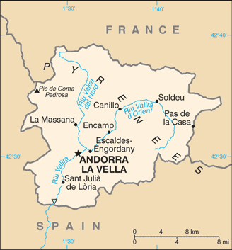
Map and Photos Planell de Laverdu


Comments

--- There are no comments yet ---


Add a new comment:


You have to log in to add a comment!


Members area


Register

Forgot password?

Andorra (Andorra La Vella):

Advertisement


GPS points near Planell de Laverdú

GPS points from Andorra (Andorra La Vella)

square Canal De Bartreta Parroquia De Canillo

square Serrat De Rudielles Andorra (general)

square Canal Del Grau Parroquia De Canillo

square Riu De La Palanqueta Parroquia De Canillo

square Basses De La Cebollera Andorra (general)

square Collet De Roques Negres Andorra (general)

square Cylindre D' Ascobes Andorra (general)

square Riu De Caborreu Andorra (general)


viewweather.com sv.ViewWeather.com
fr.ViewWeather.com
da.ViewWeather.com
de.ViewWeather.com
es.ViewWeather.com
www.carpati.org
www.searchromania.net
Deblocari usi
es.getamap.org
fr.getamap.org
de.getamap.org
nl.getamap.org
da.getamap.org
www.getamap.org
Links
Terms of use
Privacy policy

# 0.0776 sec 

contact AT getamap.net

© 2006 - 2024  https://www.getamap.net/