54°4'0" N
4°43'0" W
~0m asl
08:16 (BST - UTC/GMT+1)
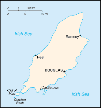
Bay ny Carrickey (Bay ny Carrickey) is a bay (class H - Hydrographic) in Isle of Man (Isle of Man (general)), Isle Of Man [ United Kingdom ] (Europe) with the region font code of Americas/Western Europe...
Bay ny Carrickey is also known as Bay ny Carrickey, Poyll Vaaish Bay.
Its coordinates are 54°4'0" N and 4°43'0" W in DMS (Degrees Minutes Seconds) or 54.0667 and -4.71667 (in decimal degrees). Its UTM position is UE89 and its Joint Operation Graphics reference is NN30-04.
Current local time is 08:16; the sun rises at 07:54 and sets at 20:01 local time (Europe/Isle_of_Man UTC/GMT+1). The standard time zone for Bay ny Carrickey is UTC/GMT+0, but since Daylight Saving Time (DST) is in effect the current time zone is UTC/GMT+1.
In 2024 DST starts on 31 Mar 2024 and ends on 27 Oct 2024.
A Bay is a coastal indentation between two capes or headlands, larger than a cove but smaller than a gulf.
|
Advertisements:
Advertisements:
|
Weather Bay ny Carrickey (Cloud cover, Temperature, Wind speed and Precipitation mm probab.)
Fri
Apr 26
6 °C min
9 °C max
17 km/h
Thu Jan 1
|
Sat
Apr 27
~3 l/m2 58%
7 °C min
9 °C max
24 km/h
Thu Jan 1
|
Sun
Apr 28
6 °C min
10 °C max
30 km/h
Thu Jan 1
|
Mon
Apr 29
~3 l/m2 61%
9 °C min
11 °C max
40 km/h
Thu Jan 1
|
Tue
Apr 30
~12 l/m2 77%
9 °C min
11 °C max
43 km/h
Thu Jan 1
|
Wed
May 1
~2 l/m2 57%
10 °C min
13 °C max
30 km/h
Thu Jan 1
|
|
|
Bay ny Carrickey (Isle of Man) 7 day forecast
Map and Photos Bay ny Carrickey
--- There are no comments yet ---
Add a new comment:
|
Members area
Isle Of Man [ United Kingdom ] (British Crown Dependency):
Advertisement
GPS points near Bay ny Carrickey
GPS points from Isle Of Man [ United Kingdom ] (British Crown Dependency)
|
 Port Mary (1 km)