|

Administrative divisions (GPS Maps)
Geography
People and Society
Government
Economy
Communications
Transportation
Military |
 |
 In 1783, the Sunni Al-Khalifa family captured Bahrain from the Persians. In order to secure these holdings, it entered into a series of treaties with the UK during the 19th century that made Bahrain a British protectorate. The archipelago attained its independence in 1971. Facing declining oil reserves, Bahrain has turned to petroleum processing and refining and has transformed itself into an international banking center. Bahrain's small size and central location among Persian Gulf countries require it to play a delicate balancing act in foreign affairs among its larger neighbors. In addition, the Sunni-led government has struggled to manage relations with its large Shia-majority population. During the mid-to-late 1990s, Shia activists mounted a low-intensity uprising to demand that the Sunni-led government stop systemic economic, social, and political discrimination against Shia Bahrainis. King HAMAD bin Isa Al-Khalifa, after succeeding his late father in 1999, pushed economic and political reforms in part to improve relations with the Shia community. After boycotting the country's first round of democratic elections under the newly-promulgated constitution in 2002, Shia political societies participated in 2006 and 2010 in legislative and municipal elections and Wifaq, the largest Shia political society, won the largest bloc of seats in the elected lower-house of the legislature both times. In early 2011, Bahrain's fractious opposition sought to ride a rising tide of popular Arab protests to petition for the redress of popular grievances. In mid-March 2011, with the backing of Gulf Cooperation Council (GCC) capitals, King HAMAD put an end to the mass public gatherings and increasingly disruptive civil disobedience by declaring a state of emergency. Manama also welcomed a contingent of mostly Saudi and Emirati forces as part of a GCC deployment intended to help Bahraini security forces maintain order. Since that time, intermittent efforts at political dialogue between the government and opposition have remained at a stalemate. The Bahrain Independent Commission of Inquiry (BICI), formed in June 2011 to investigate abuses during the unrest and state of emergency, released its final report in November 2011. The King fully endorsed the report, and since then Manama has begun to implement many of the BICI's recommendations, including improving policing procedures, reinstating fired workers, rebuilding some mosques, and establishing a compensation fund for those affected by the unrest and crackdown. Despite this progress, street protests have grown increasingly violent since the beginning of 2012. In 1783, the Sunni Al-Khalifa family captured Bahrain from the Persians. In order to secure these holdings, it entered into a series of treaties with the UK during the 19th century that made Bahrain a British protectorate. The archipelago attained its independence in 1971. Facing declining oil reserves, Bahrain has turned to petroleum processing and refining and has transformed itself into an international banking center. Bahrain's small size and central location among Persian Gulf countries require it to play a delicate balancing act in foreign affairs among its larger neighbors. In addition, the Sunni-led government has struggled to manage relations with its large Shia-majority population. During the mid-to-late 1990s, Shia activists mounted a low-intensity uprising to demand that the Sunni-led government stop systemic economic, social, and political discrimination against Shia Bahrainis. King HAMAD bin Isa Al-Khalifa, after succeeding his late father in 1999, pushed economic and political reforms in part to improve relations with the Shia community. After boycotting the country's first round of democratic elections under the newly-promulgated constitution in 2002, Shia political societies participated in 2006 and 2010 in legislative and municipal elections and Wifaq, the largest Shia political society, won the largest bloc of seats in the elected lower-house of the legislature both times. In early 2011, Bahrain's fractious opposition sought to ride a rising tide of popular Arab protests to petition for the redress of popular grievances. In mid-March 2011, with the backing of Gulf Cooperation Council (GCC) capitals, King HAMAD put an end to the mass public gatherings and increasingly disruptive civil disobedience by declaring a state of emergency. Manama also welcomed a contingent of mostly Saudi and Emirati forces as part of a GCC deployment intended to help Bahraini security forces maintain order. Since that time, intermittent efforts at political dialogue between the government and opposition have remained at a stalemate. The Bahrain Independent Commission of Inquiry (BICI), formed in June 2011 to investigate abuses during the unrest and state of emergency, released its final report in November 2011. The King fully endorsed the report, and since then Manama has begun to implement many of the BICI's recommendations, including improving policing procedures, reinstating fired workers, rebuilding some mosques, and establishing a compensation fund for those affected by the unrest and crackdown. Despite this progress, street protests have grown increasingly violent since the beginning of 2012. |
|
Advertisements
|
Advertisements
|
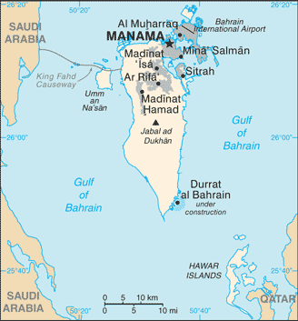
Location
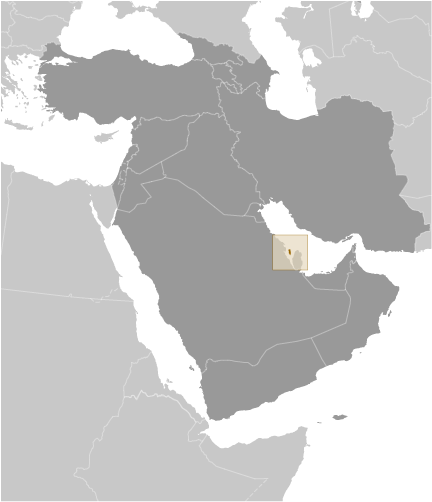
Middle East, archipelago in the Persian Gulf, east of Saudi Arabia
Geographic coordinates
26 00 N, 50 33 E
Map references
Area World Ranking: 188
Total 760 sq km
Land 760 sq km
Water 0 sq km
Area - comparative
3.5 times the size of Washington, DC
Land boundaries
0 km
Coastline
161 km
Maritime claims
Territorial sea 12 nm Contiguous zone 24 nm Continental shelf Extending to boundaries to be determined
Climate
Arid; mild, pleasant winters; very hot, humid summers
Terrain
Mostly low desert plain rising gently to low central escarpment
Elevation extremes
Lowest point Persian Gulf 0 m
Highest point Jabal ad Dukhan 122 m
Natural resources
Oil, associated and nonassociated natural gas, fish, pearls
Land use
Arable land 2.82%
Permanent crops 5.63%
Other 91.55% (2005)
Irrigated land
40 sq km (2003)
Total renewable water resources
0.1 cu km (1997)
Freshwater withdrawal (domestic/industrial/agricultural)
Total 0.3 cu km/yr (40%/3%/57%)
Per capita 411 cu m/yr (2000)
Natural hazards
Periodic droughts; dust storms
Environment - current issues
Desertification resulting from the degradation of limited arable land, periods of drought, and dust storms; coastal degradation (damage to coastlines, coral reefs, and sea vegetation) resulting from oil spills and other discharges from large tankers, oil refineries, and distribution stations; lack of freshwater resources (groundwater and seawater are the only sources for all water needs)
Environment - international agreements
Party to Biodiversity, Climate Change, Climate Change-Kyoto Protocol, Desertification, Hazardous Wastes, Law of the Sea, Ozone Layer Protection, Wetlands Signed, but not ratified None of the selected agreements
Geography - note
Close to primary Middle Eastern petroleum sources; strategic location in Persian Gulf, through which much of the Western world's petroleum must transit to reach open ocean
--- There are no comments yet ---
Add a new comment:
|
Advertisement
Members area
Bahrain (Manama):
GPS points from Bahrain (Manama)
|