26°13'0" N
90°37'60" E
~19m asl
14:07 (BTT - UTC/GMT+6)
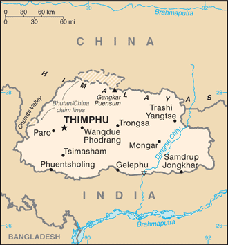
Gong Ri (Gong Ri) is a stream (class H - Hydrographic) in Bhutan (general), Bhutan (Asia) with the region font code of Asia/Pacific. It is located at an elevation of 19 meters above sea level.
Gong Ri is also known as Dangma, Dangme Chu, Danme Chu, Drangme Chhu, Gong Ri, Manas River, Manās River.
Its coordinates are 26°13'0" N and 90°37'60" E in DMS (Degrees Minutes Seconds) or 26.2167 and 90.6333 (in decimal degrees). Its UTM position is BQ60 and its Joint Operation Graphics reference is NG46-05.
Current local time is 14:07; the sun rises at 08:53 and sets at 21:00 local time (Asia/Thimphu UTC/GMT+6). The standard time zone for Gong Ri is UTC/GMT+6
In 2024 DST starts on - and ends on -.
A Stream is a body of running water moving to a lower level in a channel on land.
|
Advertisements:
Advertisements:
|
Weather Gong Ri (Cloud cover, Temperature, Wind speed and Precipitation mm probab.)
Mon
Apr 29
32 °C min
41 °C max
23 km/h
Thu Jan 1
|
Tue
Apr 30
23 °C min
43 °C max
27 km/h
Thu Jan 1
|
Wed
May 1
25 °C min
43 °C max
25 km/h
Thu Jan 1
|
Thu
May 2
~1 l/m2 13%
25 °C min
40 °C max
18 km/h
Thu Jan 1
|
Fri
May 3
~2 l/m2 38%
21 °C min
39 °C max
20 km/h
Thu Jan 1
|
Sat
May 4
22 °C min
40 °C max
14 km/h
Thu Jan 1
|
|
|
Drangme Chhu (Bhutan (general)) 7 day forecast
--- There are no comments yet ---
Add a new comment:
|
Advertisement
Members area
Bhutan (Thimphu):
GPS points from Bhutan (Thimphu)
 Ritang Wangdue Phodrang Dzongkhag
|