|
|
|
Erh-shih-li-p'u
Weather Erh-shih-li-p'u (Cloud cover, Temperature, Wind speed and Precipitation mm probab.)
Map and Photos Erh-shih-li-p'u
Comments
Add a new comment: |
Members area
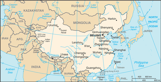
China (Beijing):
Advertisement
GPS points near Erh-shih-li-p'u
 Erh-shih-li-p'u (0.5km)
Ershilipu (0.5km)
Nanzhang (4 km)
Sanshilipu (5 km)
Wangfuji (5 km)
Balitun (6 km)
K'ang-chuang-i (7 km)
Kangyi (7 km)
Kangzhuangyi (7 km)
Shaozhuang (8 km)
Liying (9 km)
Shushan Hu (9 km)
Lake Shushan'khu (9 km)
Nantangyang (10 km)
Changgou (10 km)
Dadianzi (10 km)
Chi-ning (12 km)
Erh-shih-li-p'u (0.5km)
Ershilipu (0.5km)
Nanzhang (4 km)
Sanshilipu (5 km)
Wangfuji (5 km)
Balitun (6 km)
K'ang-chuang-i (7 km)
Kangyi (7 km)
Kangzhuangyi (7 km)
Shaozhuang (8 km)
Liying (9 km)
Shushan Hu (9 km)
Lake Shushan'khu (9 km)
Nantangyang (10 km)
Changgou (10 km)
Dadianzi (10 km)
Chi-ning (12 km)
GPS points from China (Beijing)
|