|
|
|
Hsia-liu-kou
Weather Hsia-liu-kou (Cloud cover, Temperature, Wind speed and Precipitation mm probab.)
Map and Photos Hsia-liu-kou
Comments
Add a new comment: |
Members area
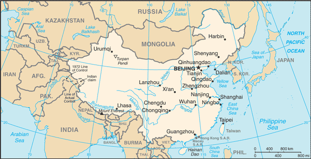
China (Beijing):
Advertisement
GPS points near Hsia-liu-kou
 Hsia-liu-kou (0.5km)
Xialiugou (0.5km)
Ma-chia-wa (4 km)
Majiahe (4 km)
Majiawa (4 km)
Datun (6 km)
Ta-t'un-ts'un (6 km)
Tianjiadatun (6 km)
T'ien-chia-ta-t'un (6 km)
Mahuangtou (6 km)
Gaojiabu (7 km)
Kao-chia-pao (7 km)
Kao-chia-pao-ts'un (7 km)
Nan-han-ching (7 km)
Nanhanjing (7 km)
Dongpingtai (9 km)
Tung-p'ing-t'ai (9 km)
Hsia-liu-kou (0.5km)
Xialiugou (0.5km)
Ma-chia-wa (4 km)
Majiahe (4 km)
Majiawa (4 km)
Datun (6 km)
Ta-t'un-ts'un (6 km)
Tianjiadatun (6 km)
T'ien-chia-ta-t'un (6 km)
Mahuangtou (6 km)
Gaojiabu (7 km)
Kao-chia-pao (7 km)
Kao-chia-pao-ts'un (7 km)
Nan-han-ching (7 km)
Nanhanjing (7 km)
Dongpingtai (9 km)
Tung-p'ing-t'ai (9 km)
GPS points from China (Beijing)
|