|
|
|
Tall Jinar
Weather Tall Jinar (Cloud cover, Temperature, Wind speed and Precipitation mm probab.)
Map and Photos Tall Jinar
Comments
Add a new comment: |
Members area
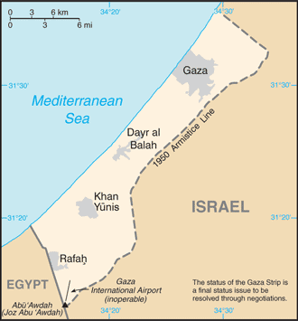
Gaza Strip:
Advertisement
GPS points near Tall Jinar
 Newe Deqalim (1 km)
Al Mawasi (2 km)
El-Mawasi (2 km)
Kefar Yam (2 km)
Tall Ridan (2 km)
Tell Ridan (2 km)
Ganne Tal (3 km)
Gadid (3 km)
Gan Or (4 km)
Abu Himar (4 km)
Abu Himer (4 km)
Hanut Yona (4 km)
Khan Younes (4 km)
Khan Yumus (4 km)
Khan Yunis (4 km)
Khan Yunus (4 km)
Yunas (4 km)
Newe Deqalim (1 km)
Al Mawasi (2 km)
El-Mawasi (2 km)
Kefar Yam (2 km)
Tall Ridan (2 km)
Tell Ridan (2 km)
Ganne Tal (3 km)
Gadid (3 km)
Gan Or (4 km)
Abu Himar (4 km)
Abu Himer (4 km)
Hanut Yona (4 km)
Khan Younes (4 km)
Khan Yumus (4 km)
Khan Yunis (4 km)
Khan Yunus (4 km)
Yunas (4 km)
GPS points from Gaza Strip
|