|
|
Advertisements:
TransportationAirports World Ranking: 65
88 (2012)
Airports - with paved runways
Total 8
Over 3,047 m 1 2,438 to 3,047 m 3 1,524 to 2,437 m 3 914 to 1,523 m 1 (2012) Airports - with unpaved runways
Total 80
2,438 to 3,047 m 1 1,524 to 2,437 m 5 914 to 1,523 m 53 Under 914 m 21 (2012) Pipelines
Oil 771 km (2010)
Railways World Ranking: 69
Total 2,157 km
Narrow gauge 2,157 km 1.067-m gauge Note Includes 891 km of the Tanzania-Zambia Railway Authority (TAZARA) (2008) Roadways World Ranking: 53
Total 91,440 km
Paved 20,117 km Unpaved 71,323 km (2001) Waterways World Ranking: 39
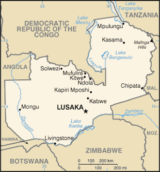
2,250 km (includes Lake Tanganyika and the Zambezi and Luapula rivers) (2010) Ports and terminals
Mpulungu
Comments
Add a new comment: |
Advertisement
Members area
Zambia (Lusaka):
 
GPS points from Zambia (Lusaka)
|
||||||||

 The territory of Northern Rhodesia was administered by the [British] South Africa Company from 1891 until it was taken over by the UK in 1923. During the 1920s and 1930s, advances in mining spurred development and immigration. The name was changed to Zambia upon independence in 1964. In the 1980s and 1990s, declining copper prices, economic mismanagement and a prolonged drought hurt the economy. Elections in 1991 brought an end to one-party rule, but the subsequent vote in 1996 saw blatant harassment of opposition parties. The election in 2001 was marked by administrative problems with three parties filing a legal petition challenging the election of ruling party candidate Levy MWANAWASA. MWANAWASA was reelected in 2006 in an election that was deemed free and fair. Upon his abrupt death in August 2008, he was succeeded by his Vice President Rupiah BANDA, who subsequently won a special presidential by-election in October 2008. Michael SATA was elected President in September 2011.