English   Română   Español   Français   Deutsch  

getamap.net

Africa

Oceania

Asia

North America

Europe

South America

Antarctica


Umm Na'san

(Umm an Na`san) / Al Wusta

26°8'59" N
50°24'0" E
~3m asl
12:08 (AST - UTC/GMT+3)

Umm Na'san (Umm Na'san) is a island (class T - Hypsographic) in Al Wusta (Al Mintaqah al Gharbiyah), Bahrain (Asia) with the region font code of Africa/Middle East. It is located at an elevation of 3 meters above sea level.
Umm Na'san is also known as Al-Na`san, Al-Na‘sān, Jazirat Umm Na`san, Jazīrat Umm Na‘sān, Um Nasan Island, Umm Na'asan, Umm Na'san, Umm Nasam Island, Umm Nasan Island, Umm Na’asān, Umm Na’san, Umm an Na`san, Umm an Na‘sān, Umm an-Nassan, أُمّ اَلنَّعْسَان.

Its coordinates are 26°8'59" N and 50°24'0" E in DMS (Degrees Minutes Seconds) or 26.1497 and 50.4 (in decimal degrees). Its UTM position is VJ49 and its Joint Operation Graphics reference is NG39-06.

Current local time is 12:08; the sun rises at 08:54 and sets at 21:01 local time (Asia/Bahrain UTC/GMT+3). The standard time zone for Umm Na'san is UTC/GMT+3
In 2024 DST starts on - and ends on -.

A Island is a tract of land, smaller than a continent, surrounded by water at high water.


Country
 Advertisements:


 Advertisements:


Weather Umm Na'san (Cloud cover, Temperature, Wind speed and Precipitation mm probab.)

Fri


Apr 26
Clound 0-0-0-20
 
25 °C min
30 °C max
18 km/h
Thu Jan 1

Sat


Apr 27
Clound 0-0-60-70
 
25 °C min
31 °C max
17 km/h
Thu Jan 1

Sun


Apr 28
Clound 0-0-20-20 Lightning
 
26 °C min
32 °C max
26 km/h
Thu Jan 1

Mon


Apr 29
Clound 0-0-30-20 Lightning
 
26 °C min
32 °C max
26 km/h
Thu Jan 1

Tue


Apr 30
Clound 0-0-50-50 Lightning
 
26 °C min
31 °C max
24 km/h
Thu Jan 1

Wed


May 1
Clound 0-10-50-70 Lightning
 
25 °C min
29 °C max
38 km/h
Thu Jan 1

Weather Graph

Umm an Na`san (Al Wusta) 7 day forecast
 

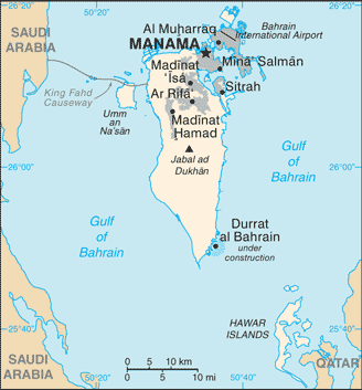
Map and Photos Umm Na'san


Comments

--- There are no comments yet ---


Add a new comment:


You have to log in to add a comment!


Members area


Register

Forgot password?

Bahrain (Manama):

Advertisement


GPS points near Umm Na'san

square Bandar Jasra (3 km)


square Cliff Island (4 km)

square Djida (4 km)

square Jeddah (4 km)

square Jida Island (4 km)

square Jiddah (4 km)

square Jazirat Jidi (4 km)

square Ras Jasra (5 km)


square Al-Djasra (5 km)

square Al Jasrah (5 km)

square Jasra (5 km)

square Jasrah (5 km)

square Jesera (5 km)

square Al Hamalah (5 km)

square Al-Hamla (5 km)


GPS points from Bahrain (Manama)

square Kaliya Bahrain (general)

square Rumaithah Al Janubiyah

square Matallah Bay Al Mintaqah Al Gharbiyah

square Marwadi Al Mintaqah Ash Shamaliyah

square Muharraq Al Muharraq

square Mamlahat Al Matallah Al Janubiyah

square `ayn Abu Zaydan Al Manamah

square Al Muwaylighah Al Asimah


viewweather.com sv.ViewWeather.com
fr.ViewWeather.com
da.ViewWeather.com
de.ViewWeather.com
es.ViewWeather.com
www.carpati.org
www.searchromania.net
Deblocari usi
es.getamap.org
fr.getamap.org
de.getamap.org
nl.getamap.org
da.getamap.org
www.getamap.org
Links
Terms of use
Privacy policy

# 0.0627 sec 

contact AT getamap.net

© 2006 - 2024  https://www.getamap.net/