|
|
|
Advertisements:
GeographyLocation
Central Africa, north of Democratic Republic of the Congo Geographic coordinates
7 00 N, 21 00 E
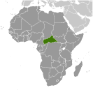
Map references
Africa
Area World Ranking: 45
Total 622,984 sq km
Land 622,984 sq km Water 0 sq km Area - comparative
Slightly smaller than Texas
Land boundaries
Total 5,203 km
Border countries Cameroon 797 km, Chad 1,197 km, Democratic Republic of the Congo 1,577 km, Republic of the Congo 467 km, South Sudan 990 km, Sudan 175 km Coastline
0 km (landlocked)
Maritime claims
None (landlocked)
Climate
Tropical; hot, dry winters; mild to hot, wet summers Terrain
Vast, flat to rolling, monotonous plateau; scattered hills in northeast and southwest Elevation extremes
Lowest point Oubangui River 335 m
Highest point Mont Ngaoui 1,420 m Natural resources
Diamonds, uranium, timber, gold, oil, hydropower Land use
Arable land 3.1%
Permanent crops 0.15% Other 96.75% (2005) Irrigated land
10 sq km (2003)
Total renewable water resources
144.4 cu km (2003)
Freshwater withdrawal (domestic/industrial/agricultural)
Total 0.03 cu km/yr (80%/16%/4%)
Per capita 7 cu m/yr (2000) Natural hazards
Hot, dry, dusty harmattan winds affect northern areas; floods are common Environment - current issues
Tap water is not potable; poaching has diminished the country's reputation as one of the last great wildlife refuges; desertification; deforestation Environment - international agreements
Party to
Biodiversity, Climate Change, Climate Change-Kyoto Protocol, Desertification, Endangered Species, Hazardous Wastes, Ozone Layer Protection, Tropical Timber 94, Wetlands Signed, but not ratified Law of the SeaGeography - note
Landlocked; almost the precise center of Africa
Comments
Add a new comment: |
Advertisement
Members area
Central African Republic (Bangui):
 
GPS points from Central African Republic (Bangui)
|
||||||||

 The former French colony of Ubangi-Shari became the Central African Republic upon independence in 1960. After three tumultuous decades of misrule - mostly by military governments - civilian rule was established in 1993 and lasted for one decade. President Ange-Felix PATASSE's civilian government was plagued by unrest, and in March 2003 he was deposed in a military coup led by General Francois BOZIZE, who established a transitional government. Though the government has the tacit support of civil society groups and the main parties, a wide field of candidates contested the municipal, legislative, and presidential elections held in March and May of 2005 in which General BOZIZE was affirmed as president. BOZIZE was reelected in the 2011 elections, which were widely viewed as having gross inaccuracies and discrepancies. The government still does not fully control the countryside, where pockets of lawlessness persist. Militant group Lord's Resistance Army (LRA) continues to affect stability in the Central African Republic as well.