|
|
Advertisements:
TransportationAirports World Ranking: 106
40 (2012)
Airports - with paved runways
Total 2
2,438 to 3,047 m 1 1,524 to 2,437 m 1 (2012) Airports - with unpaved runways
Total 38
2,438 to 3,047 m 1 1,524 to 2,437 m 12 914 to 1,523 m 19 Under 914 m 6 (2012) Roadways World Ranking: 105
Total 24,307 km (2000)
Waterways World Ranking: 35
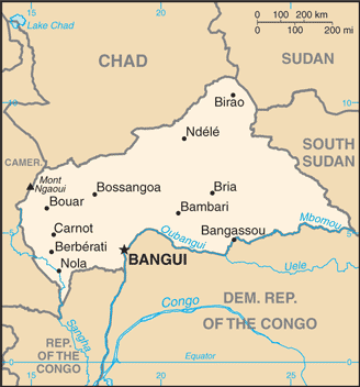
2,800 km (the primary navigable river is the Ubangi, which joins the River Congo; it was the traditional route for the export of products because it connected with the Congo-Ocean railway at Brazzaville; because of the warfare on both sides of the River Congo from 1997, however, routes through Cameroon became preferred by importers and exporters) (2011) Ports and terminals
Bangui, Nola, Salo, Nzinga
Comments
Add a new comment: |
Advertisement
Members area
Central African Republic (Bangui):
 
GPS points from Central African Republic (Bangui)
|
||||||||

 The former French colony of Ubangi-Shari became the Central African Republic upon independence in 1960. After three tumultuous decades of misrule - mostly by military governments - civilian rule was established in 1993 and lasted for one decade. President Ange-Felix PATASSE's civilian government was plagued by unrest, and in March 2003 he was deposed in a military coup led by General Francois BOZIZE, who established a transitional government. Though the government has the tacit support of civil society groups and the main parties, a wide field of candidates contested the municipal, legislative, and presidential elections held in March and May of 2005 in which General BOZIZE was affirmed as president. BOZIZE was reelected in the 2011 elections, which were widely viewed as having gross inaccuracies and discrepancies. The government still does not fully control the countryside, where pockets of lawlessness persist. Militant group Lord's Resistance Army (LRA) continues to affect stability in the Central African Republic as well.