|
|
|
Advertisements:
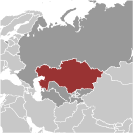
GeographyLocation
Central Asia, northwest of China; a small portion west of the Ural (Zhayyq) River in eastern-most Europe Geographic coordinates
48 00 N, 68 00 E
Map references
Asia
Area World Ranking: 9
Total 2,724,900 sq km
Land 2,699,700 sq km Water 25,200 sq km Area - comparative
Slightly less than four times the size of Texas Land boundaries
Total 12,185 km
Border countries China 1,533 km, Kyrgyzstan 1,224 km, Russia 6,846 km, Turkmenistan 379 km, Uzbekistan 2,203 km Coastline
0 km (landlocked); note - Kazakhstan borders the Aral Sea, now split into two bodies of water (1,070 km), and the Caspian Sea (1,894 km) Maritime claims
None (landlocked)
Climate
Continental, cold winters and hot summers, arid and semiarid Terrain
Vast flat steppe extending from the Volga in the west to the Altai Mountains in the east and from the plains of western Siberia in the north to oases and deserts of Central Asia in the south Elevation extremes
Lowest point Vpadina Kaundy -132 m
Highest point Khan Tangiri Shyngy (Pik Khan-Tengri) 6,995 m Natural resources
Major deposits of petroleum, natural gas, coal, iron ore, manganese, chrome ore, nickel, cobalt, copper, molybdenum, lead, zinc, bauxite, gold, uranium Land use
Arable land 8.28%
Permanent crops 0.05% Other 91.67% (2005) Irrigated land
35,560 sq km (2003)
Total renewable water resources
109.6 cu km (1997)
Freshwater withdrawal (domestic/industrial/agricultural)
Total 35 cu km/yr (2%/17%/82%)
Per capita 2,360 cu m/yr (2000) Natural hazards
Earthquakes in the south; mudslides around Almaty Environment - current issues
Radioactive or toxic chemical sites associated with former defense industries and test ranges scattered throughout the country pose health risks for humans and animals; industrial pollution is severe in some cities; because the two main rivers that flowed into the Aral Sea have been diverted for irrigation, it is drying up and leaving behind a harmful layer of chemical pesticides and natural salts; these substances are then picked up by the wind and blown into noxious dust storms; pollution in the Caspian Sea; soil pollution from overuse of agricultural chemicals and salination from poor infrastructure and wasteful irrigation practices Environment - international agreements
Party to
Air Pollution, Biodiversity, Climate Change, Desertification, Endangered Species, Environmental Modification, Hazardous Wastes, Ozone Layer Protection, Ship Pollution, Wetlands Signed, but not ratified Climate Change-Kyoto ProtocolGeography - note
Landlocked; Russia leases approximately 6,000 sq km of territory enclosing the Baykonur Cosmodrome; in January 2004, Kazakhstan and Russia extended the lease to 2050
Comments
Add a new comment: |
Advertisement
Members area
Kazakhstan (Astana):
 
GPS points from Kazakhstan (Astana)
|
||||||||

 Ethnic Kazakhs, a mix of Turkic and Mongol nomadic tribes who migrated into the region in the 13th century, were rarely united as a single nation. The area was conquered by Russia in the 18th century, and Kazakhstan became a Soviet Republic in 1936. During the 1950s and 1960s agricultural "Virgin Lands" program, Soviet citizens were encouraged to help cultivate Kazakhstan's northern pastures. This influx of immigrants (mostly Russians, but also some other deported nationalities) skewed the ethnic mixture and enabled non-ethnic Kazakhs to outnumber natives. Independence in 1991 drove many of these newcomers to emigrate. Kazakhstan's economy is larger than those of all the other Central Asian states largely due to the country's vast natural resources. Current issues include: developing a cohesive national identity; expanding the development of the country's vast energy resources and exporting them to world markets; diversifying the economy outside the oil, gas, and mining sectors; enhancing Kazakhstan's economic competitiveness; developing a multiparty parliament and advancing political and social reform; and strengthening relations with neighboring states and other foreign powers.