|
|
|
Advertisements:
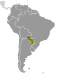
GeographyLocation
Central South America, northeast of Argentina, southwest of Brazil Geographic coordinates
23 00 S, 58 00 W
Map references
South America
Area World Ranking: 60
Total 406,752 sq km
Land 397,302 sq km Water 9,450 sq km Area - comparative
Slightly smaller than California Land boundaries
Total 3,995 km
Border countries Argentina 1,880 km, Bolivia 750 km, Brazil 1,365 km Coastline
0 km (landlocked)
Maritime claims
None (landlocked)
Climate
Subtropical to temperate; substantial rainfall in the eastern portions, becoming semiarid in the far west Terrain
Grassy plains and wooded hills east of Rio Paraguay; Gran Chaco region west of Rio Paraguay mostly low, marshy plain near the river, and dry forest and thorny scrub elsewhere Elevation extremes
Lowest point
Junction of Rio Paraguay and Rio Parana 46 m Highest point Cerro Pero 842 mNatural resources
Hydropower, timber, iron ore, manganese, limestone Land use
Arable land 7.47%
Permanent crops 0.24% Other 92.29% (2005) Irrigated land
670 sq km (2003)
Total renewable water resources
336 cu km (2000)
Freshwater withdrawal (domestic/industrial/agricultural)
Total 0.49 cu km/yr (20%/8%/71%)
Per capita 80 cu m/yr (2000) Natural hazards
Local flooding in southeast (early September to June); poorly drained plains may become boggy (early October to June) Environment - current issues
Deforestation; water pollution; inadequate means for waste disposal pose health risks for many urban residents; loss of wetlands Environment - international agreements
Party to
Biodiversity, Climate Change, Climate Change-Kyoto Protocol, Desertification, Endangered Species, Hazardous Wastes, Law of the Sea, Ozone Layer Protection, Wetlands Signed, but not ratified None of the selected agreements Geography - note
Landlocked; lies between Argentina, Bolivia, and Brazil; population concentrated in southern part of country
Comments
Add a new comment: |
Advertisement
Members area
Paraguay (Asuncion):
 
GPS points from Paraguay (Asuncion)
|
||||||||

 Paraguay achieved its independence from Spain in 1811. In the disastrous War of the Triple Alliance (1865-70) - between Paraguay and Argentina, Brazil, and Uruguay - Paraguay lost two-thirds of all adult males and much of its territory. The country stagnated economically for the next half century. Following the Chaco War of 1932-35 with Bolivia, Paraguay gained a large part of the Chaco lowland region. The 35-year military dictatorship of Alfredo STROESSNER ended in 1989, and, despite a marked increase in political infighting in recent years, Paraguay has held relatively free and regular presidential elections since then.