26°8'40" N
50°38'31" E
~0m asl
16:51 (AST - UTC/GMT+3)
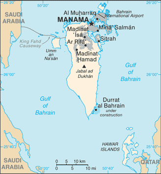
Port of Sitra (Port of Sitra) is a oil pipeline terminal (class S - Spot Feature) in Ash Shamaliyah (Sitrah), Bahrain (Asia) with the region font code of Africa/Middle East...
Port of Sitra is also known as Port of Sitra, Port of Sitrah, Sitra, Sitra Oil Loading Terminal, Sitra Terminal, Sitrah, Sitrah Anchorage, sitrat, سِتْرَة.
Its coordinates are 26°8'40" N and 50°38'31" E in DMS (Degrees Minutes Seconds) or 26.1444 and 50.6419 (in decimal degrees). Its UTM position is VJ69 and its Joint Operation Graphics reference is NG39-06.
Current local time is 16:51; the sun rises at 08:54 and sets at 21:01 local time (Asia/Bahrain UTC/GMT+3). The standard time zone for Port of Sitra is UTC/GMT+3
In 2024 DST starts on - and ends on -.
A Oil pipeline terminal is a tank farm or loading facility at the end of an oil pipeline.
|
Advertisements:
Advertisements:
|
Weather Port of Sitra (Cloud cover, Temperature, Wind speed and Precipitation mm probab.)
Sat
Apr 27
28 °C min
30 °C max
16 km/h
Thu Jan 1
|
Sun
Apr 28
26 °C min
31 °C max
26 km/h
Thu Jan 1
|
Mon
Apr 29
26 °C min
31 °C max
23 km/h
Thu Jan 1
|
Tue
Apr 30
26 °C min
30 °C max
30 km/h
Thu Jan 1
|
Wed
May 1
~2 l/m2 47%
24 °C min
28 °C max
48 km/h
Thu Jan 1
|
Thu
May 2
~11 l/m2 82%
23 °C min
29 °C max
34 km/h
Thu Jan 1
|
|
|
Sitrah (Ash Shamaliyah) 7 day forecast
Map and Photos Port of Sitra
--- There are no comments yet ---
Add a new comment:
|
Members area
Bahrain (Manama):
Advertisement
GPS points near Port of Sitra
GPS points from Bahrain (Manama)
|
 Bandar ad Da (1 km)