English   Română   Español   Français   Deutsch  

getamap.net

Africa

Oceania

Asia

North America

Europe

South America

Antarctica


Baía de Ana de Chaves

(Ponta de Sao Sebastiao) / Sao Tome

0°21'0" N
6°43'60" E
~145m asl
22:49 (GMT - UTC/GMT+0)

Baia de Ana de Chaves (Baía de Ana de Chaves) is a bay (class H - Hydrographic) in Sao Tome (São Tomé), Sao Tome And Principe (Africa) with the region font code of Americas/Western Europe. It is located at an elevation of 145 meters above sea level.

Its coordinates are 0°21'0" N and 6°43'60" E in DMS (Degrees Minutes Seconds) or 0.35 and 6.73333 (in decimal degrees). Its UTM position is KF43 and its Joint Operation Graphics reference is NA32-13.

Current local time is 22:49; the sun rises at 08:53 and sets at 21:00 local time (Africa/Sao_Tome UTC/GMT+0). The standard time zone for Baia de Ana de Chaves is UTC/GMT+0
In 2024 DST starts on - and ends on -.

A Bay is a coastal indentation between two capes or headlands, larger than a cove but smaller than a gulf.


Country
 Advertisements:


 Advertisements:


Weather Baía de Ana de Chaves (Cloud cover, Temperature, Wind speed and Precipitation mm probab.)

Sun


Apr 28
Clound 0-10-0-90
~1 l/m2 21%
 
29 °C min
30 °C max
16 km/h
Thu Jan 1

Mon


Apr 29
Clound 0-10-30-90 Lightning
~1 l/m2 36%
 
29 °C min
30 °C max
13 km/h
Thu Jan 1

Tue


Apr 30
Clound 0-10-10-90 Lightning
~3 l/m2 31%
 
28 °C min
30 °C max
18 km/h
Thu Jan 1

Wed


May 1
Clound 20-0-50-90 Lightning
~9 l/m2 52%
 
28 °C min
30 °C max
17 km/h
Thu Jan 1

Thu


May 2
Clound 0-10-60-70 Lightning
~3 l/m2 51%
 
28 °C min
30 °C max
21 km/h
Thu Jan 1

Fri


May 3
Clound 20-10-10-70
~5 l/m2 30%
 
28 °C min
30 °C max
20 km/h
Thu Jan 1

Weather Graph

Ponta de Sao Sebastiao (Sao Tome) 7 day forecast
 

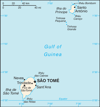
Map and Photos Baia de Ana de Chaves


Comments

--- There are no comments yet ---


Add a new comment:


You have to log in to add a comment!


Members area


Register

Forgot password?

Sao Tome And Principe (Sao Tome):

Advertisement


GPS points near Baía de Ana de Chaves

square Salazar (1 km)

square Sao Thome (1 km)

square Sao Tome (1 km)


square Oquedelrei (1 km)

square Oquedelrey (1 km)


square Praia Lagarto (2 km)

square Rio Melo (2 km)

square Nazare (2 km)

square Agua Telha (2 km)

square Praia Pequena (2 km)


square Bombon (3 km)


square Bela Vista (4 km)


GPS points from Sao Tome And Principe (Sao Tome)

square Rio Do Ouro Sao Tome

square Sant'elmo Sao Tome

square Ile Du Principe Principe

square Mutamba Sao Tome


square Fernao Dias Sao Tome


square Focinho De Cao Principe


viewweather.com sv.ViewWeather.com
fr.ViewWeather.com
da.ViewWeather.com
de.ViewWeather.com
es.ViewWeather.com
www.carpati.org
www.searchromania.net
Deblocari usi
es.getamap.org
fr.getamap.org
de.getamap.org
nl.getamap.org
da.getamap.org
www.getamap.org
Links
Terms of use
Privacy policy

# 0.9167 sec 

contact AT getamap.net

© 2006 - 2024  https://www.getamap.net/