English   Română   Español   Français   Deutsch  

getamap.net

Africa

Oceania

Asia

North America

Europe

South America

Antarctica


Monte Joana de Sousa

/ Sao Tome

0°10'60" N
6°28'0" E
~0m asl
07:34 (GMT - UTC/GMT+0)

Monte Joana de Sousa (Monte Joana de Sousa) is a hill (class T - Hypsographic) in Sao Tome (São Tomé), Sao Tome And Principe (Africa) with the region font code of Americas/Western Europe...
Monte Joana de Sousa is also known as Monte Joana de Sousa, Monte Juliana, Morro Joana de Souza.

Its coordinates are 0°10'60" N and 6°28'0" E in DMS (Degrees Minutes Seconds) or 0.183333 and 6.46667 (in decimal degrees). Its UTM position is KF12 and its Joint Operation Graphics reference is NA32-13.

Current local time is 07:34; the sun rises at 08:54 and sets at 21:01 local time (Africa/Sao_Tome UTC/GMT+0). The standard time zone for Monte Joana de Sousa is UTC/GMT+0
In 2024 DST starts on - and ends on -.

A Hill is a rounded elevation of limited extent rising above the surrounding land with local relief of less than 300m.


Country
 Advertisements:


 Advertisements:


Weather Monte Joana de Sousa (Cloud cover, Temperature, Wind speed and Precipitation mm probab.)

Sat


Apr 27
Clound 10-10-10-80
~0.4 l/m2 15%
 
28 °C min
30 °C max
15 km/h
Thu Jan 1

Sun


Apr 28
Clound 0-10-0-70
~4 l/m2 36%
 
28 °C min
30 °C max
17 km/h
Thu Jan 1

Mon


Apr 29
Clound 0-10-20-100 Lightning
~3 l/m2 39%
 
28 °C min
30 °C max
16 km/h
Thu Jan 1

Tue


Apr 30
Clound 20-10-30-90 Lightning
~6 l/m2 37%
 
28 °C min
30 °C max
14 km/h
Thu Jan 1

Wed


May 1
Clound 20-10-40-100 Lightning
~9 l/m2 52%
 
28 °C min
29 °C max
19 km/h
Thu Jan 1

Thu


May 2
Clound 20-10-50-80 Lightning
~8 l/m2 58%
 
28 °C min
29 °C max
22 km/h
Thu Jan 1

Weather Graph

Monte Joana de Sousa (Sao Tome) 7 day forecast
 

Map and Photos Monte Joana de Sousa


Comments

--- There are no comments yet ---


Add a new comment:


You have to log in to add a comment!


Members area


Register

Forgot password?

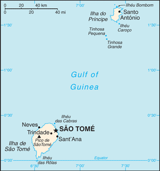
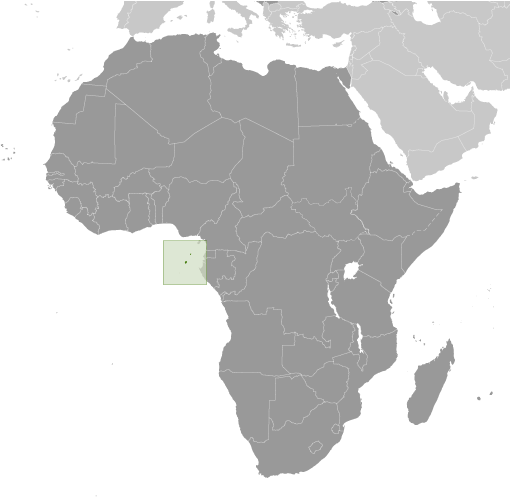
Sao Tome And Principe (Sao Tome):

Advertisement


GPS points near Monte Joana de Sousa


square Rio Edgar (1 km)


square Ilheo Coco (1 km)

square Ilheu Coco (1 km)


square Sao Manoel (2 km)


square Sao Manuel (2 km)

square Capitu (2 km)

square Kapitu (2 km)

square Binda (3 km)

square Praia Binda (3 km)

square Rio Binda (3 km)

square Ponta Gryobo (4 km)

square Safu (4 km)

square Monteverde (5 km)


GPS points from Sao Tome And Principe (Sao Tome)

square Sao Joao Principe

square Ilheu Santana Principe

square Morro Sintra Sao Tome

square Ile Du Principe Principe

square Praia Micondo Sao Tome

square Ponta Das Burras Principe

square Portinho Sao Tome

square Praia Nazare Principe


viewweather.com sv.ViewWeather.com
fr.ViewWeather.com
da.ViewWeather.com
de.ViewWeather.com
es.ViewWeather.com
www.carpati.org
www.searchromania.net
Deblocari usi
es.getamap.org
fr.getamap.org
de.getamap.org
nl.getamap.org
da.getamap.org
www.getamap.org
Links
Terms of use
Privacy policy

# 0.0634 sec 

contact AT getamap.net

© 2006 - 2024  https://www.getamap.net/