|
|
|
Advertisements:
GeographyLocation
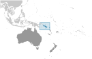
Oceania, group of islands in the South Pacific Ocean, east of Papua New Guinea Geographic coordinates
8 00 S, 159 00 E
Map references
Oceania
Area World Ranking: 144
Total 28,896 sq km
Land 27,986 sq km Water 910 sq km Area - comparative
Slightly smaller than Maryland
Land boundaries
0 km
Coastline
5,313 km
Maritime claims
Measured from claimed archipelagic baselines Territorial sea 12 nmExclusive economic zone 200 nm Continental shelf 200 nm Climate
Tropical monsoon; few extremes of temperature and weather Terrain
Mostly rugged mountains with some low coral atolls Elevation extremes
Lowest point Pacific Ocean 0 m
Highest point Mount Popomanaseu 2,310 m Natural resources
Fish, forests, gold, bauxite, phosphates, lead, zinc, nickel Land use
Arable land 0.62%
Permanent crops 2.04% Other 97.34% (2005) Irrigated land
NA
Total renewable water resources
44.7 cu km (1987)
Natural hazards
Typhoons, but rarely destructive; geologically active region with frequent earthquakes, tremors, and volcanic activity; tsunamis Volcanism Tinakula (elev. 851 m) has frequent eruption activity, while an eruption of Savo (elev. 485 m) could affect the capital Honiara on nearby Guadalcanal Environment - current issues
Deforestation; soil erosion; many of the surrounding coral reefs are dead or dying Environment - international agreements
Party to
Biodiversity, Climate Change, Climate Change-Kyoto Protocol, Desertification, Environmental Modification, Law of the Sea, Marine Dumping, Marine Life Conservation, Ozone Layer Protection, Whaling Signed, but not ratified None of the selected agreements Geography - note
Strategic location on sea routes between the South Pacific Ocean, the Solomon Sea, and the Coral Sea; on 2 April 2007 an undersea earthquake measuring 8.1 on the Richter scale occurred 345 km WNW of the capital Honiara; the resulting tsunami devastated coastal areas of Western and Choiseul provinces with dozens of deaths and thousands dislocated; the provincial capital of Gizo was especially hard hit
Comments
Add a new comment: |
Advertisement
Members area
Solomon Islands (Honiara):
 
GPS points from Solomon Islands (Honiara)
|
||||||||

 The UK established a protectorate over the Solomon Islands in the 1890s. Some of the most bitter fighting of World War II occurred on this archipelago. Self-government was achieved in 1976 and independence two years later. Ethnic violence, government malfeasance, and endemic crime have undermined stability and civil society. In June 2003, then Prime Minister Sir Allan KEMAKEZA sought the assistance of Australia in reestablishing law and order; the following month, an Australian-led multinational force arrived to restore peace and disarm ethnic militias. The Regional Assistance Mission to the Solomon Islands (RAMSI) has generally been effective in restoring law and order and rebuilding government institutions.