|
|
Advertisements:
TransportationAirports World Ranking: 92
47 (2012)
Airports - with paved runways
Total 5
Over 3,047 m 1 Under 914 m 4 (2012) Airports - with unpaved runways
Total 42
914 to 1,523 m 4 Under 914 m 38 (2012) Pipelines
Oil 50 km (2010)
Roadways World Ranking: 154
Total 4,304 km
Paved 1,130 km Unpaved 3,174 km (2003) Waterways World Ranking: 61
1,200 km (most navigable by ships with drafts up to 7 m) (2011) Ports and terminals
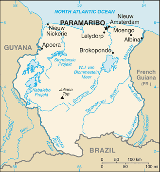
Paramaribo, Wageningen
Comments
Add a new comment: |
Advertisement
Members area
Suriname (Paramaribo):
 
GPS points from Suriname (Paramaribo)
|
||||||||

 First explored by the Spaniards in the 16th century and then settled by the English in the mid-17th century, Suriname became a Dutch colony in 1667. With the abolition of slavery in 1863, workers were brought in from India and Java. Independence from the Netherlands was granted in 1975. Five years later the civilian government was replaced by a military regime that soon declared a socialist republic. It continued to exert control through a succession of nominally civilian administrations until 1987, when international pressure finally forced a democratic election. In 1990, the military overthrew the civilian leadership, but a democratically elected government - a four-party coalition - returned to power in 1991. The coalition expanded to eight parties in 2005 and ruled until August 2010, when voters returned former military leader Desire BOUTERSE and his opposition coalition to power.