|
|
|
Advertisements:
GeographyLocation
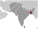
Southern Asia, bordering the Bay of Bengal, between Burma and India Geographic coordinates
24 00 N, 90 00 E
Map references
Asia
Area World Ranking: 95
Total 143,998 sq km
Land 130,168 sq km Water 13,830 sq km Area - comparative
Slightly smaller than Iowa
Land boundaries
Total 4,246 km
Border countries Burma 193 km, India 4,053 km Coastline
580 km
Maritime claims
Territorial sea 12 nm
Contiguous zone 18 nm Exclusive economic zone 200 nm Continental shelf Up to the outer limits of the continental margin Climate
Tropical; mild winter (October to March); hot, humid summer (March to June); humid, warm rainy monsoon (June to October) Terrain
Mostly flat alluvial plain; hilly in southeast Elevation extremes
Lowest point Indian Ocean 0 m
Highest point Keokradong 1,230 m Natural resources
Natural gas, arable land, timber, coal Land use
Arable land 55.39%
Permanent crops 3.08% Other 41.53% (2005) Irrigated land
50,500 sq km (2003)
Total renewable water resources
1,210.6 cu km (1999)
Freshwater withdrawal (domestic/industrial/agricultural)
Total 79.4 cu km/yr (3%/1%/96%)
Per capita 560 cu m/yr (2000) Natural hazards
Droughts; cyclones; much of the country routinely inundated during the summer monsoon season Environment - current issues
Many people are landless and forced to live on and cultivate flood-prone land; waterborne diseases prevalent in surface water; water pollution, especially of fishing areas, results from the use of commercial pesticides; ground water contaminated by naturally occurring arsenic; intermittent water shortages because of falling water tables in the northern and central parts of the country; soil degradation and erosion; deforestation; severe overpopulation Environment - international agreements
Party to
Biodiversity, Climate Change, Climate Change-Kyoto Protocol, Desertification, Endangered Species, Environmental Modification, Hazardous Wastes, Law of the Sea, Ozone Layer Protection, Ship Pollution, Wetlands Signed, but not ratified None of the selected agreements Geography - note
Most of the country is situated on deltas of large rivers flowing from the Himalayas: the Ganges unites with the Jamuna (main channel of the Brahmaputra) and later joins the Meghna to eventually empty into the Bay of Bengal
Comments
Add a new comment: |
Advertisement
Members area
Bangladesh (Dhaka):
 
GPS points from Bangladesh (Dhaka)
|
||||||||

 Europeans began to set up trading posts in the area of Bangladesh in the 16th century; eventually the British came to dominate the region and it became part of British India. In 1947, West Pakistan and East Bengal (both primarily Muslim) separated from India (largely Hindu) and jointly became the new country of Pakistan. East Bengal became East Pakistan in 1955, but the awkward arrangement of a two-part country with its territorial units separated by 1,600 km left the Bengalis marginalized and dissatisfied. East Pakistan seceded from its union with West Pakistan in 1971 and was renamed Bangladesh. A military-backed, emergency caretaker regime suspended parliamentary elections planned for January 2007 in an effort to reform the political system and root out corruption. In contrast to the strikes and violent street rallies that had marked Bangladeshi politics in previous years, the parliamentary elections finally held in late December 2008 were mostly peaceful and Sheikh HASINA Wajed was elected prime minister. About a third of this extremely poor country floods annually during the monsoon rainy season, hampering economic development.