|
|
Advertisements:
GovernmentCountry name
Conventional long form
People's Republic of Bangladesh Conventional short form BangladeshLocal long form Gana Prajatantri Bangladesh Local short form Bangladesh Former East Bengal, East Pakistan Government type
Parliamentary democracy
Capital
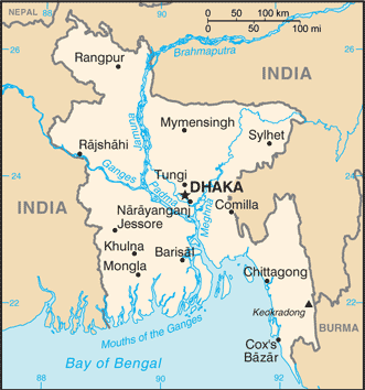
Name Dhaka
Geographic coordinates 23 43 N, 90 24 E Time difference UTC+6 (11 hours ahead of Washington, DC during Standard Time) Administrative divisions
7 divisions; Barisal, Chittagong, Dhaka, Khulna, Rajshahi, Rangpur, Sylhet Independence
16 December 1971 (from West Pakistan); note - 26 March 1971 is the date of independence from West Pakistan, 16 December 1971 is known as Victory Day and commemorates the official creation of the state of Bangladesh National holiday
Independence Day, 26 March (1971); note - 26 March 1971 is the date of independence from West Pakistan, 16 December 1971 is Victory Day and commemorates the official creation of the state of Bangladesh Constitution
Enacted 4 November 1972; effective 16 December 1972; suspended following coup of 24 March 1982; restored 10 November 1986; amended many times Legal system
Mixed legal system of mostly English common law and Islamic law International law organization participation
Has not submitted an ICJ jurisdiction declaration; accepts ICCt jurisdiction Suffrage
18 years of age; universal
Executive branch
Chief of state
President Zillur RAHMAN (since 12 February 2009) Head of government Prime Minister Sheikh HASINA Wajed (since 6 January 2009) Cabinet Cabinet selected by the prime minister and appointed by the president Elections President elected by National Parliament for a five-year term (eligible for a second term); last election held on 11 February 2009 (next to be held in 2014) Election results Zillur RAHMAN declared president-elect by the Election Commission on 11 February 2009 (sworn in on 12 February); he ran unopposed as president; percent of National Parliament vote - NA Legislative branch
Unicameral National Parliament or Jatiya Sangsad; 300 seats (45 reserved for women) elected by popular vote from single territorial constituencies; members serve five-year terms Elections Last held on 29 December 2008; note - general elections must be held within 90 days of the expiration of the Parliament or by 29 March 2014 or earlier if Parliament is dissolved before its term expires Election results Percent of vote by party - AL 49%, BNP 33.2%, JP 7%, JIB 4.6%, other 6.2%; seats by party - AL 230, BNP 30, JP 27, JIB 2, other 11 Judicial branch
Supreme Court (the chief justices and other judges are appointed by the president) Political parties and leaders
Awami League or AL [Sheikh HASINA]; Communist Party of Bangladesh or CPB [Manjurul A. KHAN]; Bangladesh Nationalist Party or BNP [Khaleda ZIA]; Bikalpa Dhara Bangladesh or BDB [Badrudozza CHOWDHURY]; Islami Oikya Jote or IOJ [multiple leaders]; Jamaat-e-Islami Bangladesh or JIB [Matiur Rahman NIZAMI]; Jatiya Party or JP (Ershad faction) [Hussain Mohammad ERSHAD]; Liberal Democratic Party or LDP [Oli AHMED] Political pressure groups and leaders
Advocacy to End Gender-based Violence through the MoWCA (Ministry of Women's and Children's Affairs) Other Environmentalists; Islamist groups; religious leaders; teachers; union leaders International organization participation
ADB, ARF, BIMSTEC, C, CICA (observer), CP, D-8, FAO, G-77, IAEA, IBRD, ICAO, ICC, ICRM, IDA, IDB, IFAD, IFC, IFRCS, IHO, ILO, IMF, IMO, IMSO, Interpol, IOC, IOM, IPU, ISO, ITSO, ITU, ITUC, MIGA, MINURSO, MONUSCO, NAM, OIC, OPCW, SAARC, SACEP, UN, UNAMID, UNCTAD, UNESCO, UNHCR, UNIDO, UNIFIL, UNISFA, UNMIL, UNMISS, UNMIT, UNOCI, UNWTO, UPU, WCO, WFTU, WHO, WIPO, WMO, WTO Diplomatic representation in the us
Chief of mission Ambassador Akramul QADER
Chancery 3510 International Drive NW, Washington, DC 20008 Telephone [1] (202) 244-0183FAX [1] (202) 244-7830/2771 Consulate(s) general Los Angeles, New York Diplomatic representation from the us
Chief of mission Ambassador Dan W. MOZENA
Embassy Madani Avenue, Baridhara, Dhaka 1212 Mailing address G. P. O. Box 323, Dhaka 1000Telephone [880] (2) 885-5500 FAX [880] (2) 882-3744 Flag description
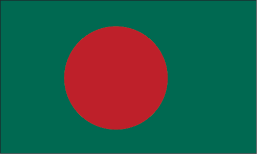
Green field with a large red disk shifted slightly to the hoist side of center; the red disk represents the rising sun and the sacrifice to achieve independence; the green field symbolizes the lush vegetation of Bangladesh National symbol(s)
Bengal tiger
National anthem
Name
"Amar Shonar Bangla" (My Golden Bengal) Lyrics/music Rabindranath TAGORENote Adopted 1971; Rabindranath TAGORE, a Nobel laureate, also wrote India's national anthem
Comments
Add a new comment: |
Advertisement
Members area
Bangladesh (Dhaka):
 
GPS points from Bangladesh (Dhaka)
|
||||||||

 Europeans began to set up trading posts in the area of Bangladesh in the 16th century; eventually the British came to dominate the region and it became part of British India. In 1947, West Pakistan and East Bengal (both primarily Muslim) separated from India (largely Hindu) and jointly became the new country of Pakistan. East Bengal became East Pakistan in 1955, but the awkward arrangement of a two-part country with its territorial units separated by 1,600 km left the Bengalis marginalized and dissatisfied. East Pakistan seceded from its union with West Pakistan in 1971 and was renamed Bangladesh. A military-backed, emergency caretaker regime suspended parliamentary elections planned for January 2007 in an effort to reform the political system and root out corruption. In contrast to the strikes and violent street rallies that had marked Bangladeshi politics in previous years, the parliamentary elections finally held in late December 2008 were mostly peaceful and Sheikh HASINA Wajed was elected prime minister. About a third of this extremely poor country floods annually during the monsoon rainy season, hampering economic development.