|
|
|
Advertisements:
Administrative divisions (963 GPS Maps)
Comments
Add a new comment: |
Advertisement
Members area
Tonga (Nuku'alofa):
 
GPS points from Tonga (Nuku'alofa)
|
||||||||
|
|
|
Advertisements:
Administrative divisions (963 GPS Maps)
Comments
Add a new comment: |
Advertisement
Members area
Tonga (Nuku'alofa):
GPS points from Tonga (Nuku'alofa)
|
||||||||

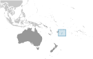 Tonga - unique among Pacific nations - never completely lost its indigenous governance. The archipelagos of "The Friendly Islands" were united into a Polynesian kingdom in 1845. Tonga became a constitutional monarchy in 1875 and a British protectorate in 1900; it withdrew from the protectorate and joined the Commonwealth of Nations in 1970. Tonga remains the only monarchy in the Pacific.