|
|
Advertisements:
TransportationAirports World Ranking: 6
1,149 (2012)
Airports - with paved runways
Total 159
Over 3,047 m 4 2,438 to 3,047 m 28 1,524 to 2,437 m 64 914 to 1,523 m 54 Under 914 m 9 (2012) Airports - with unpaved runways
Total 990
Over 3,047 m 1 2,438 to 3,047 m 1 1,524 to 2,437 m 45 914 to 1,523 m 499 Under 914 m 444 (2012) Heliports
2 (2012)
Pipelines
Gas 29,401 km; liquid petroleum gas 41 km; oil 6,166 km; refined products 3,631 km (2010) Railways World Ranking: 8
Total 36,966 km
Broad gauge 26,475 km 1.676-m gauge (94 km electrified) Standard gauge 2,780 km 1.435-m gauge (42 km electrified) Narrow gauge 7,711 km 1.000-m gauge (2008)Roadways World Ranking: 22
Total 231,374 km
Paved 69,412 km (includes 734 km of expressways) Unpaved 161,962 km (2004)Waterways World Ranking: 12
11,000 km (2012)
Merchant marine World Ranking: 80
Total 36
By type Bulk carrier 1, cargo 5, chemical tanker 6, container 1, passenger/cargo 1, petroleum tanker 18, refrigerated cargo 4 Foreign-owned 14 (Brazil 1, Chile 6, Spain 3, Taiwan 2, UK 2) Registered in other countries 15 (Liberia 1, Panama 5, Paraguay 5, Uruguay 1, unknown 3) (2010) Ports and terminals
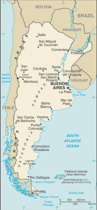
Arroyo Seco, Bahia Blanca, Buenos Aires, La Plata, Punta Colorada, Rosario, San Lorenzo-San Martin, Ushuaia
Comments
Add a new comment: |
Advertisement
Members area
Argentina (Buenos Aires):
 
GPS points from Argentina (Buenos Aires)
|
||||||||

 In 1816, the United Provinces of the Rio Plata declared their independence from Spain. After Bolivia, Paraguay, and Uruguay went their separate ways, the area that remained became Argentina. The country's population and culture were heavily shaped by immigrants from throughout Europe, but most particularly Italy and Spain, which provided the largest percentage of newcomers from 1860 to 1930. Up until about the mid-20th century, much of Argentina's history was dominated by periods of internal political conflict between Federalists and Unitarians and between civilian and military factions. After World War II, an era of Peronist populism and direct and indirect military interference in subsequent governments was followed by a military junta that took power in 1976. Democracy returned in 1983 after a failed bid to seize the Falkland Islands (Islas Malvinas) by force, and has persisted despite numerous challenges, the most formidable of which was a severe economic crisis in 2001-02 that led to violent public protests and the successive resignations of several presidents.